
Places near here
Photo credits
- National Inventory of Architectural Heritage
- David Dixon, Wikimedia Commons · CC BY-SA 2.0
- Vadim Manuylov, Wikimedia Commons · CC BY-SA 3.0
- Eric Hunt, Wikimedia Commons · CC BY 2.5
- Blimey74, Wikimedia Commons · CC0
- David Dixon, Geograph · CC BY-SA 2.0
- RTG, Wikimedia Commons · CC BY-SA 4.0
- P L Chadwick, Geograph · CC BY-SA 2.0
- Philip Halling, Geograph · CC BY-SA 2.0
- Colin Park, Geograph · CC BY-SA 2.0
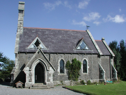 Killoteran ChurchChurch/chapel · 13 yd
Explorer Tom Killoteran Church is planning its retirement by quietly turning into a local landmark. It was designed in 1858 with such care that it’s outlived every other building nearby, so now it just watches the seasons change from its peaceful spot, waiting for someone to finally notice its mid-nineteenth-century charm.
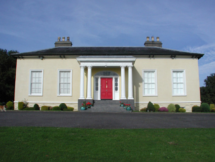 Killoteran HouseHouse · 710 yd
Explorer Tom Killoteran House in Woodstown is positioned perfectly to watch the River Suir meander by. It’s got that villa vibe with a portico that looks like it’s waiting for important visitors who never come. The view over the rolling grounds is probably better than my excuse for being late. Stand on the public path and enjoy the scenic silence.
 Mount Congreve GardensVisitor attraction · 1516 yd
Explorer Tom Mount Congreve Gardens in County Waterford is where the Vikings got so lost they ended up gardening instead of raiding. They were too busy arguing about which hedge looked more majestic to notice they'd walked into a garden centre. Stop the car, it's worth the hazard lights.
 Monterey Cypress1.2 mi
Explorer Tom Monterey Cypress in County Waterford has made a New Year's resolution to stop being so pointy, but it doesn’t seem to be working out for him. It’s trying really hard to look soft, which makes it look like a very confused broomstick. Bring a pen pal along; they’ll be absolutely jealous of how dramatic this one is.
 Sweet michelia1.2 mi
Explorer Tom Sweet michelia in County Waterford is being picked on by the wind because it smells too nice and everyone wants a sniff. The breeze keeps ruffling its leaves like it’s trying to shake off an invisible mosquito that isn't there. Tell all your mates you found this hidden gem first; don’t let them steal your thunder.
 Corluddy Castle (in Ruins)Castle, tower house · 1.5 mi
Explorer Tom Corluddy Castle has been hiding a scandal for centuries. Probably a bad bet on horses in 1600 that nobody admitted to. It’s just sitting there, looking vaguely guilty and very muddy. Pop by and tell it it's looking well.
 CastleCastle, unclassified · 1.6 mi
Explorer Tom Castle in Kilmeadan has a bird that refuses to leave, even though the castle is mostly just a suggestion of a building. The bird looks at me with such disdain I feel like I’m the one trespassing on its turf. Pack a picnic and an excuse.
 DolmenPortal tomb · 2.7 mi
Explorer Tom Gaulstown Dolmen is stuck in a fairy dispute over parking rights for its massive roofstone. It’s facing the hillside like it’s eavesdropping on the next ridge’s gossip. Dare you to say hello to it out loud.
 Gaulstown Portal TombArchaeological place · 2.7 mi
Explorer Tom Gaulstown Portal Tomb has a family tree that is ninety percent invented by my uncle, who also claims he knows the king. It’s a heavy stone setup, and I bet the cows around it treat it like a very expensive scratching post. Wave at the cows, they're the real locals.
 Kilfarrasy BeachBeach / strand · 7.8 mi
Explorer Tom Kilfarrasy Beach would tell you in a job interview that it has excellent rock management skills and zero complaints from the gulls. It’s very confident about its disappearing act during high tide. Best enjoyed with a bag of chips and no plans.
 Lime KilnVisitor information · 7.9 mi
Explorer Tom Lime Kiln is sitting up above Annestown beach, whispering tales of a hidden tunnel that leads straight to the best pint in County Waterford. People say if you scratch the side just right, you can hear the ghosts arguing about who left the stove on. It’s got a smoky secret and a reputation for being slightly haunted by past workers. Stand there long enough and someone will ask if you're lost.
 Annestown BeachBeach / strand · 8.0 mi
Explorer Tom Annestown Beach in County Waterford is where a local poet fell into a ditch while reciting verses about tides, which ruined his socks and his reputation. He never recovered, but the beach looks great because he stopped complaining so much. Bring a flask of something strong and pretend you own the entire coastline right now.
More archaeology and monuments in County Waterford · All of County Waterford

What do you know about this place?Tap to add a comment or ask a question