
What is recorded here
From the National Monuments Service (Archaeological Survey of Ireland) record CO077-043001
Places near here
Photo credits
- Maker not stated on source page, www.dreamstime.com
- Maker not stated on source page, pixabay.com
- Hywel Williams, Geograph · CC BY-SA 2.0
- Maker not stated on source page, heritageireland.ie
- Mike Searle, Geograph · CC BY-SA 2.0
- National Inventory of Architectural Heritage
- FON Community Sports Complex / Smart Lotto; individual photographer not stated, smartlotto.ie
- Kmcnamee, Wikimedia Commons · CC BY-SA 4.0
- Maker not stated on source page, www.pinterest.com
- Andy Beecroft, Geograph · CC BY-SA 2.0
 Kilcredan Church of Ireland GraveyardGraveyard · 4 yd
Explorer Tom Kilcredan Church of Ireland Graveyard in County Cork is supposedly guarded by a giant who only wakes up if you sneeze…
 Church (in Ruins)Church · 5 yd
Explorer Tom Church in Kilcredan is just a roofless rectangle pretending to be spiritual. I swear it smells like old bread and…
 Kilcredan Church of Ireland ChurchGraveyard/cemetery · 14 yd
Explorer Tom Kilcredan Church of Ireland Church graveyard holds the final resting place of Robert Tynte and his grieving widow's…
 Fairy fort / earthen ringfort in RathhahaFairy fort / earthen ringfort · 1250 yd
Explorer Tom Fairy fort / earthen ringfort in Rathhaha is a circular bank incorporated into the field system, with a stone face on…
 Garryvoe Castle (in Ruins)Castle, tower house · 1.2 mi
Explorer Tom Garryvoe Castle is hiding under the ivy like a shy kid. It has a wicker-centred vault, which sounds fancy but is…
 Clonmaine HouseHouse · 1.4 mi
Explorer Tom Clonmaine House has small windows set in a broad wall, which is either minimalist or shy. It retains its heritage…
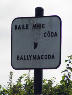 sign post1.8 mi
Explorer Tom Sign post in Ballydaniel is chatting in both Irish and English, dating back to the early 1940s. The harp motif says…
 Fr. O' Neills GAA pitchGAA ground · 2.1 mi
 Russell Rovers GAA pitchGAA ground · 3.1 mi
 Fairy fort / earthen ringfort in Ballybane (imokilly By.)Fairy fort / earthen ringfort · 3.3 mi
Explorer Tom Fairy fort / earthen ringfort in Ballybane has a two-metre bank that’s been levelled on one side. It’s basically a flat…
 CastleBawn · 4.2 mi
Explorer Tom Castle bawn in Ballymaloe More is just a low square tower sitting in the yard. Part of the wall still survives on the…
 N25 Picnic SitePicnic place · 5.1 mi
Explorer Tom N25 Picnic Site was designed by a mother-in-law who hated traffic and loved passive aggression. It’s wedged so tight…
More archaeology and monuments in County Cork · All of County Cork

What do you know about this place?Tap to add a comment or ask a question