Places near here
Photo credits
- National Inventory of Architectural Heritage
- 2ManyCats4Me, Wikimedia Commons · CC0
- Eric Jones, Geograph · Creative Commons Attribution-ShareAlike 2.0
- Granard Motte.png : Smcq Derivative work: Hogweard, Wikimedia Commons · CC BY-SA 3.0
- Kmcnamee, Wikimedia Commons · CC BY-SA 4.0
- Gillaween, Wikimedia Commons · CC BY-SA 4.0
- Charles T. G. Clarke, Wikimedia Commons · CC BY-SA 4.0
- Wanfried-Dublin, Wikimedia Commons · CC BY-SA 4.0
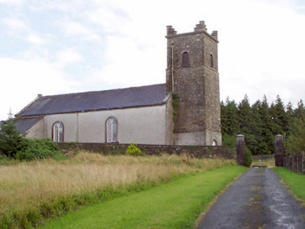 Saint Patrick's Church (Granard)Church/chapel · 26 yd
Explorer Tom Saint Patrick's Church in Granard has a rivalry with more famous spots because it’s got a Diocletian window. It was…
 Granard MotteMotte-and-bailey castle remains · 119 yd
Explorer Tom Granard Motte would describe the 1800s to a teenager as 'basically a long queue for nothing'. It's just a big mound…
 Saint Mary's Catholic ChurchChurch/chapel · 121 yd
Explorer Tom Saint Mary's Catholic Church in Moatfield, County Longford refuses to fall down because it knows it looks better…
 1798 MonumentMonument · 147 yd
Explorer Tom The 1798 Monument in Granard uses a Celtic high cross style to tell you about a battle that happened two hundred years…
 Moat of GranardCastle, motte and bailey · 168 yd
Explorer Tom The local sheep at Granard Moat rate it a solid four stars for grass quality. Richard de Tuit built it in 1199 to fight…
 Higginstown, St. Mary's GAA, GranardGAA ground · 1114 ydBallybrien, BallymoreGAA ground · 1.5 mi
 Sheela-na-gig in AbbeylaraSheela-na-gig · 2.4 mi
Explorer Tom Sheela-na-gig in Abbeylara has been staring into the void for centuries, and I swear she’s judging your outfit while…
CartronfreeMountain / peak · 3.1 miExplorer Tom Cartronfree is basically the matchmaker who works up there, pairing every hilltop with a different legend. She’s loud…
Clonfin Ambush MemorialMemorial · 3.6 miExplorer Tom Clonfin Ambush Memorial in Longford is secretly proud of the one potato that survived the battle unscathed, hidden…
 Coolamber CastleHouse, fortified house · 4.7 mi
Explorer Tom Coolamber Castle House is where Saint Patrick would have said, ‘You’ve got a bit of an ego for a pile of rocks.’…
 Portal tomb in AghnacliffPortal tomb · 6.3 mi
Explorer Tom Portal tomb in Aghnacliff has survived storms that would make a modern tent weep with despair. It stands tall while one…
More archaeology and monuments in County Longford · All of County Longford

What do you know about this place?Tap to add a comment or ask a question