Places near here
Photo credits
- National Inventory of Architectural Heritage
- Maker named on the Wikimedia Commons picture page · CC BY-SA 2.5
- Joebater at English Wikipedia, Wikimedia Commons · CC BY-SA 3.0
- Donald MacDonald, Geograph · CC BY-SA 2.0
- me, Wikimedia Commons · Public domain
- Ceoil ( talk ) ( Uploads ), Wikimedia Commons · Public domain
- Jonathan Thacker, Geograph · CC BY-SA 2.0
 Coolcour HouseCountry house · 943 yd
Explorer Tom Coolcour House was burned during the Troubles but came back in the 1920s looking fresher than ever. It’s got an eighteenth-century core that’s been extended and remodelled, so it’s basically a time-traveling house with a new coat of paint. Have a look around the gate lodge!
St Bernards WellHoly well · 1168 ydExplorer Tom St Bernards Well has cement steps and a plaque for a saint whose name sounds like a sneeze. People used to do rounds here on Palm Sunday while pretending they weren't sweaty. Stand still and listen, the wind tells it better than me.
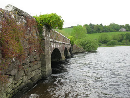 Annahala BridgeBridge · 1500 yd
Explorer Tom Annahala Bridge over the Gearagh River is now just a pedestrian walkway because cars got too big for its taste. It’s got cutwaters and a limestone stringcourse that scream craftsmanship. Go in good spirits if you cross it.
 Sessile Oak1504 yd
Explorer Tom Sessile Oak in County Cork would post on social media: 'Another day, another leaf falling. #NatureIsIndifferent.' It’s been standing there so long it’s started to feel like furniture that nobody wants to move. The bark is thick enough to hide a secret or two. Ring your granny and tell her where you are.
 Battle of MacroomBattle · 1.0 mi
Explorer Tom The Battle of Macroom is constantly trying to one-up its more famous cousin next door by claiming it had better weather and a superior supply of biscuits, which is why the soldiers fought with such enthusiasm and zero dignity. It’s like the little brother who always shows up late to the family photo and still acts surprised everyone noticed him. If it’s closed, admire it from the road like a polym
 Macroom Castle (in Ruins)Castle, tower house · 1.1 mi
Explorer Tom Macroom Castle got demolished in 1967 to build a technical school, which is either genius or terrible. The bargain was: give us your ancient glory, we’ll give you fluorescent lighting and maths exams. It’s the only castle that died for education, bless it. Bring sandwiches, the gulls will thank you.
Macroom WalksVisitor information · 1.2 miExplorer Tom Macroom Walks in County Cork has strict rules for visitors, including one where you have to pretend the ducks are wearing tiny hats to get full points. It’s a walking route that feels like it’s leading you somewhere important but actually just loops back to the start. Tell the kids it's a castle. Close enough.
Burial Ground (Disused)Burial ground · 1.4 miExplorer Tom Burial Ground (Disused) in Gurteenroe was swallowed by a private garden because someone needed more space for their roses. It’s marked disused and incorporated into the plot. Knock on the door if you feel brave enough!
 The Gearagh Nature ReserveNature reserve · 2.0 mi
Explorer Tom The Gearagh Nature Reserve remembers the time a priest lost a bet there and had to wear a penguin suit for a week, which was undignified. The reeds are still giggling about it. Take a mate and argue about what it was for.
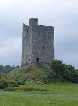 Carrigaphooca CastleCastle · 3.4 mi
Explorer Tom Carrigaphooca Castle has a púca in its name and a rock under its feet, enough for me to spin a tale before we even reach Macroom. The MacCarthys of Muskerry built the five-storey tower in the early fifteenth century above the River Sullane. Its name means castle on the rock of the púca, a supernatural character from Irish stories; I will not claim a ghost was the builder. Stone-circle and standing-stone sites lie in the wider area, giving the valley older company. The tower is cared for by the state but stands on private property and is not open to the public. View it only from a lawful public position and do not cross a fence because my tale sounds inviting. Look at the steep rock supporting the walls. Even without a púca, the builders chose a dramatic perch.
Priest MemorialMemorial · 4.0 miExplorer Tom Priest Memorial is stuck in a legal battle with the local fairies over who gets to park their little carts first. He won’t budge an inch because he has excellent lawyer friends. Have a nosey, politely.
 Kilmurry WoodsPicnic place · 4.2 mi
Explorer Tom Kilmurry Woods in County Cork had a fiddler play there all night last Tuesday, and the trees are still shaking their heads in disapproval of the tune. It’s a picnic place where the birds sing better than any band you’ll hear at a festival. Bring a flask of something warm and a story to swap.
More archaeology and monuments in County Cork · All of County Cork

What do you know about this place?Tap to add a comment or ask a question