Places near here
Photo credits
- John M, Geograph · CC BY-SA 2.0
- Philip Halling, Wikimedia Commons · CC BY-SA 2.0
- Alexander Redfern, Wikimedia Commons · CC BY-SA 4.0
- National Inventory of Architectural Heritage
- Philip Halling, Geograph · CC BY-SA 2.0
- Colin Park, Geograph · CC BY-SA 2.0
- Kmcnamee, Wikimedia Commons · CC BY-SA 4.0
- Brendan Tobin, Wikimedia Commons · CC BY-SA 4.0
- Kieran Campbell, Wikimedia Commons · CC BY-SA 2.0
 Castle (in ruins)Castle, tower house · 197 yd
Explorer Tom Castle in Dunhill, County Waterford is gone, but two families are still arguing over who gets to claim the view from…
 Dunhill CastleCastle · 198 yd
Explorer Tom Dunhill Castle in County Waterford has strong opinions about the road leading to it, mostly that it’s too bumpy for its…
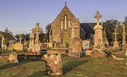 Catholic Church of the Sacred HeartOfficially recorded historic building · 1.0 mi
Explorer Tom Catholic Church of the Sacred Heart in Dunhill refuses to fall down because it’s too stubborn to admit it’s tired. The…
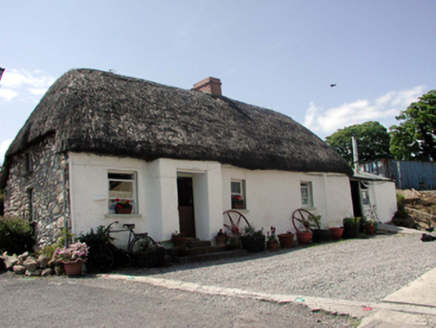 The ThatchHouse · 1.1 mi
Explorer Tom The Thatch in Ballynageeragh is keeping its roof so dry it could probably make a sandwich for us all. The local sheep…
 Lime KilnVisitor information · 1.3 mi
Explorer Tom Lime Kiln is sitting up above Annestown beach, whispering tales of a hidden tunnel that leads straight to the best pint…
 Annestown BeachBeach / strand · 1.3 mi
Explorer Tom Annestown Beach sits on Waterford's Copper Coast with a sea arch, an offshore island and a castellated old limekiln…
 Páirc Ui Bhriain, DunhillGAA ground · 1.4 mi
 Ballinageeragh DolmenArchaeological place · 1.5 mi
Explorer Tom Ballinageeragh Dolmen claims Queen Victoria stopped by for a quick sniff in 1845, but nobody has the diary entry to…
 Fenor BogNature reserve · 1.8 mi
Explorer Tom Fenor Bog sits beside the church in a Waterford village, a wet little world where the boardwalk crosses sedge, willow…
William Flynn Park, FenorGAA ground · 1.8 mi Boatstrand BeachBeach / strand · 2.0 mi
Explorer Tom Boatstrand Beach shares its little Waterford inlet with a harbour and pier, so a visit can feel like finding a seaside…
 Matthewstown Passage TombArchaeological place · 2.1 mi
Explorer Tom Matthewstown Passage Tomb is where the Vikings got so lost they ended up arguing about which way was north for three…
More archaeology and monuments in County Waterford · All of County Waterford

What do you know about this place?Tap to add a comment or ask a question