
What is recorded here
From the National Monuments Service (Archaeological Survey of Ireland) record TS082-014001
Places near here
Photo credits
- Maker not stated on source page, ru.pinterest.com
- Maker not stated on source page, www.pinterest.com
- Maker not stated on source page, en.wikipedia.org
- Mike Searle, Geograph · CC BY-SA 2.0
- Maker not stated on source page, www.irishcentral.com
- ethics girl, Geograph · CC BY-SA 2.0
- National Inventory of Architectural Heritage
- Algirdas at Lithuanian Wikipedia, Wikimedia Commons · Public domain
- Chmouel Boudjnah Original uploader was Chmouel at fr.wikipedia, Wikimedia Commons · CC BY-SA 3.0
 Derrygrath GraveyardGraveyard · 7 yd
Explorer Tom Derrygrath Graveyard would bring a massive tray of scones to any party, even if there are no guests. It’s prepared for…
 CastleCastle, unclassified · 1094 yd
Explorer Tom Castle in Derrygrath Lower is unlocated, which means nobody can find it, but one stubborn pigeon refuses to leave the…
 Earthwork in Carrickconeen,derrygrath LowerEarthwork · 1.1 mi
Explorer Tom Carrickconeen’s earthwork is having a dramatic standoff with the nearest tree, both pretending to be more important…
 Nicholastown Castle (in ruins)Castle, tower house · 1.1 mi
Explorer Tom Nicholastown Castle claims to be older than the concept of Tuesday. It sits on that limestone ledge like it’s judging…
 Nicholastown CastleCastle · 1.1 mi
Explorer Tom Nicholastown Castle in County Tipperary makes a distinct creaking sound at night that sounds suspiciously like it’s…
 Fairy fort / earthen ringfort in CarrickconeenFairy fort / earthen ringfort · 1.2 mi
Explorer Tom If this ringfort were at a wedding, it would be the uncle who shows up late, drinks too much, and gives a toast about…
 Moorstown CastleCastle, tower house · 1.3 mi
Explorer Tom Moorstown Castle is perched on that limestone outcrop looking like it’s judging your life choices with every brick. The…
 Loughlohery CastleKiln · 1.3 mi
Explorer Tom Loughlohery Castle isn’t actually a castle at all, it’s a limekiln built into the rock that thinks it’s royalty. It…
 Graveyard in GarryntempleGraveyard · 2.2 mi
Explorer Tom Graveyard in Garryntemple is buried under cabbages, which I guess is a very organic way to disappear from the map. The…
 Church in KilleenbutlerChurch · 3.1 mi
Explorer Tom Church in Killeenbutler would tell its younger self to stop hiding near the railway tracks and just be a proper church.…
 Pedunculate Oak3.8 mi
Explorer Tom Pedunculate Oak in County Tipperary was planted by a builder who was really thinking about lunch rather than the soil…
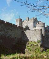 Cahir CastleHeritage attraction · 3.9 mi
Explorer Tom I came to Cahir carrying a spade; the Suir did the work first. Cahir Castle sits in the River Suir as though someone…
More archaeology and monuments in County Tipperary · All of County Tipperary

What do you know about this place?Tap to add a comment or ask a question