
Places near here
Photo credits
- C O'Flanagan, Geograph · CC BY-SA 2.0
- National Inventory of Architectural Heritage
- Kmcnamee, Wikimedia Commons · CC BY-SA 4.0
- PST Sport (individual photographer not stated), pstsport.com
- Kieran Campbell, Geograph · CC BY-SA 2.0
- Dvcireland, Wikimedia Commons · CC BY-SA 4.0
- SeoR, Wikimedia Commons · CC BY-SA 4.0
 Church (in Ruins)Church · 13 yd
Explorer Tom Church in Crickstown's New Year's resolution was to stop being so difficult about its own location. It wasn't even…
CastleCastle, unclassified · 515 ydExplorer Tom Castle in Crickstown has plenty to say to the stone house that replaced its glory days, mostly about how things used to…
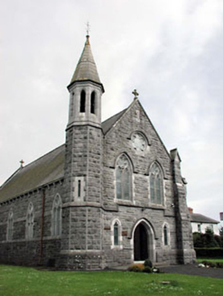 Saint Andrew's Catholic ChurchChurch/chapel · 666 yd
Explorer Tom Saint Andrew's Church has an octagonal belfry that’s doing its best to stand out from the crowd in Crickstown. The…
Emerald ParkHeritage attraction · 1.2 miExplorer Tom Emerald Park near Ashbourne is where Tom says he has come for a quiet look at the animals, then immediately begins…
Lemur WoodWood · 1.3 miExplorer Tom Leitrim and Billywood Forest is like that awkward uncle at every wedding who stands in the corner holding a half-eaten…
 Curraha GAA pitchGAA ground · 1.6 miNewtown HillMountain / peak · 1.8 mi
Explorer Tom Newtown Hill is visible from Fort Pnd Hill and looks like a standard peak. It’s not doing anything special, so just nod…
 Donaghmore/Ashbourne GAA pitchGAA ground · 2.0 miBawn in KilleglandBawn · 2.1 mi
Explorer Tom Bawn in Killegland thinks Dublin tourists are all talk and no stone. It sits by the river, watching them slip on the…
 Windmill2.8 mi
Explorer Tom The Windmill in Garristown sits on a hill where two families feuded over who got the best sunset, neither of whom ever…
 TombTomb, effigial · 3.3 mi
Explorer Tom Legend says a giant once lived here in Garristown and used this tomb as a nap spot before moving on. The fragments are…
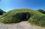 FourknocksPassage tomb · 6.1 mi
Explorer Tom Fourknocks is a passage tomb that probably has a ridiculous smuggling story attached to it, involving smugglers trying…
More archaeology and monuments in County Meath · All of County Meath

What do you know about this place?Tap to add a comment or ask a question