
Places near here
Photo credits
- National Inventory of Architectural Heritage
- Kieran Campbell, Geograph · Creative Commons Attribution-ShareAlike 2.0
- Sitomon, Wikimedia Commons · CC BY-SA 2.0
- Wanfried-Dublin, Wikimedia Commons · CC BY-SA 4.0
- Alvesgaspar, Wikimedia Commons · CC BY-SA 3.0
- Garry Dickinson, Geograph · CC BY-SA 2.0
- Jamie Carroll, Geograph · CC BY-SA 2.0
- jai, Wikimedia Commons · CC BY-SA 2.0
- Sitomon, Wikimedia Commons · Public domain
- John M, Wikimedia Commons · CC BY-SA 2.0
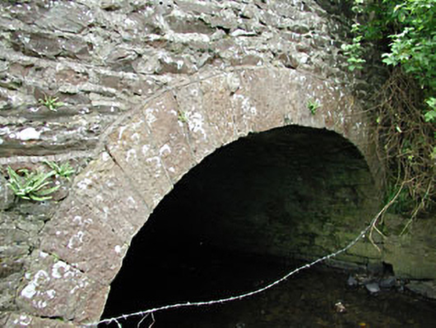 bridge1.1 mi
Explorer Tom Bridge in Benjerstown has walls made of rubble stone and dressed voussoirs that create a texture like a very rough sandpaper. The mix of limestone and sandstone gives it a weird colour palette that I can’t quite decide if I like. Just drive over it quickly and don’t stop to think too hard!
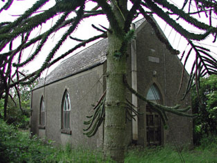 Siddan HallChurch hall/parish hall · 1.1 mi
Explorer Tom Siddan Hall in Glebe is suspicious of the postman because he keeps dropping things through the cast-iron windows. It’s a simple hall with big modern dreams and old-fashioned nerves. Go on, count the windows and whisper your fears.
 Grave YardGraveyard · 2.7 mi
Explorer Tom Graveyard in Knock wants a New Year’s resolution: to stop being so rectangularly boring and start acting mysterious again. The cross and font are there, but the church is basically a ghost. Go before the tourists find out.
 European Yew2.9 mi
Explorer Tom This European Yew is feuding with the next village over something daft, probably about who has the better shade. It’s been going on for years and nobody really cares anymore. Practise your Irish on it, it won't correct you.
 Druids AltarPortal tomb · 3.0 mi
Explorer Tom Druids Altar in Rathkenny hosted a fiddler who played all night without stopping. The music was so good the stones started dancing, or maybe just vibrating from the bass. Give it a pat on the way past, it's had a long life.
 Common Lime3.8 mi
Explorer Tom Common Lime in County Meath would tell a teenager that the 1800s were basically just a really long, damp argument with no Wi-Fi. It’s been standing there judging everyone since then. Find the date carved somewhere and feel clever.
 CastleCastle, tower house · 4.6 mi
Explorer Tom Smarmore Castle thinks tourists from Dublin are too loud and don’t know how to hold a pint. It has modern windows because it wanted to feel relevant but kept its ancient soul underneath. A good place to forget your phone for ten minutes.
 Slane CastleCastle, unclassified · 8.0 mi
Explorer Tom Slane Castle looks tough enough to survive a zombie attack by just standing there and judging everyone. It’s had a few makeovers but still acts like it owns the river. Go now, before it gets famous.
 Mellifont AbbeyVisitor attraction · 9.5 mi
Explorer Tom Mellifont Abbey in County Louth was nearly sold to pay for a horse that ran off with a nun. The monks were furious but the deal went through anyway. Bring a flask and pretend you own the place.
 Graveyard in Richardstown (ardee By., Richardstown Par.)Graveyard · 9.6 mi
Explorer Tom Richardstown’s graveyard sits in the wooded grounds of a castle with a modern top half. It is secretly proud of the potato it grew there in 1740. Dare you to say hello to it out loud.
 KnowthArchaeological place · 10 mi
Explorer Tom You see one mound? Give Knowth another minute to complicate your day. Knowth looks like one enormous grassy mound in the Boyne Valley until its stonework starts giving away the plot. The main monument, built around 3200 BC, holds two separate passages, one entering from the east and one from the west. Around its base stood 127 kerbstones, and excavators found more than 200 carved stones, including art hidden on faces that visitors would not normally have seen. If I could read every carved line, I would still let the builders keep a few secrets. That is quite a private gallery for a place already making a public impression. Centuries later people built a royal residence on top, using the old mound for a new kind of authority. Knowth is part of the Brú na Bóinne heritage complex, and visits are managed through the visitor arrangements there; check current booking and access before going. Study the carved spirals, but leave the ancient builders at least one secret they can keep.
 Brú na Bóinne Visitors CentreVisitor information · 12 mi
Explorer Tom Brú na Bóinne Visitors Centre in County Meath has very strong opinions on modern buildings, mostly that they’re too bright and not ancient enough. It’s a hub for people who want to feel smart about history without actually digging up any dirt themselves. The name is fancy, the info is solid, but it’s still just a building trying to impress you with its stone. Go now, before it gets famous
More archaeology and monuments in County Meath · All of County Meath

What do you know about this place?Tap to add a comment or ask a question