What is recorded here
A roughly rectangular graveyard (c. 80m ESE-WNW; c. 55m SSW-NNE) enclosed on the S, W and N sides by a stone wall and defined on the E side by a steep slope down to the river. The ruins of an Augustinian friary (SL037-068001-) are at the E side. There are many 18th- and 19th-century headstones and crosses, the earliest noted was dated 1775. Amongst the grave-markers are numerous architectural pieces derived from the friary, and the area immediately around the ruin is strewn with rubble, broken headstones and tomb surrounds. The graveyard has recently been partially cleared of overgrowth. The enclosed burial ground for the nearby convent of the Sisters of Charity of Banada Abbey, who are associated with Banada since the 1860s (McDonnell-Garvey 1999/2000, 9-11), is at the S side of the graveyard.
A roughly rectangular graveyard (c. 80m ESE-WNW; c. 55m SSW-NNE) enclosed on the S, W and N sides by a stone wall and defined on the E side by a steep slope down to the river. The ruins of an Augustinian friary (SL037-068001-) are at the E side. There are many 18th- and 19th-century headstones and crosses, the earliest noted was dated 1775. Amongst the grave-markers are numerous architectural pieces derived from…
From the National Monuments Service (Archaeological Survey of Ireland) record SL037-068005
The monument record does not grant public access. Check the route and ask the landowner before entering private land.
- What survives
- Recorded monument
Places near here
Photo credits
- National Inventory of Architectural Heritage
- Andreas F. Borchert, Wikimedia Commons · CC BY-SA 4.0
- Gordon Hatton, Geograph · CC BY-SA 2.0
- Richard Webb, Geograph · CC BY-SA 2.0
- Alan Reid, Geograph · CC BY-SA 2.0
- Didier Descouens, Wikimedia Commons · CC BY-SA 4.0
- Pamela Norrington, Geograph · CC BY-SA 2.0
- Newbert12, Wikimedia Commons · CC BY-SA 4.0
- JohnArmagh, Wikimedia Commons · CC BY-SA 3.0
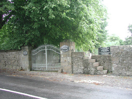 Banada GraveyardGraveyard/cemetery · 9 yd
 Banada AbbeyReligious house, Augustinian friars · 26 ydCastle (Site of)Castle, unclassified · 1.1 miBallyara Castle (in Ruins)Castle, unclassified · 2.5 mi
 Mass RockNamed rock · 4.9 mi
 Lough Talt TrailVisitor information · 5.4 mi
 Largan HillMountain / peak · 6.6 mi
 Hawthorn7.0 miHawthorn7.9 mi
 Hennigan's Heritage CentreHeritage attraction · 8.2 mi
 IndicatedWedge tomb · 10 mi
 Round Tower11 mi
More archaeology and monuments in County Sligo · All of County Sligo
What do you know about this place?