What is recorded here
Glenturk Lodge in Glenturk Beg is an empty shooting lodge, which must look a tremendous bargain to the birds. ‘Lovely place. Previous owner had a difficult attitude towards tenants.’
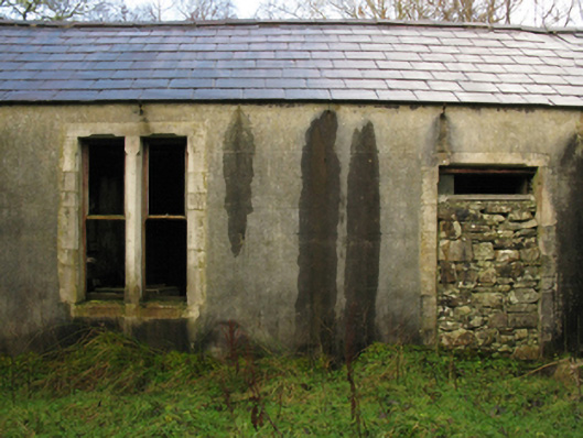
Detached three-bay single-storey shooting lodge, between 1864-76, on a U-shaped plan with pair of single-bay (single-bay deep) single-storey returns (east). Occupied, 1901; 1911. Now disused. Pitched slate roof on a U-shaped plan on collared timber construction with clay ridge tiles, rendered chimney stacks on axis with ridge having stepped capping, remains of timber bargeboards to gables on timber purlins, and no rainwater goods surviving on rendered eaves. Rendered, ruled and lined walls with drag edged tooled cut-limestone flush quoins to corners. Square-headed central door opening with drag edged tooled cut-limestone surround having chamfered reveals framing rubble stone infill. Square-headed flanking window openings in bipartite arrangement with drag edged tooled cut-limestone surrounds having chamfered reveals framing remains of one-over-one timber sash windows. Shouldered square-headed central open internal porch to rear (east) elevation with drag edged tooled cut-limestone block-and-start surround having chamfered reveals. Interior in ruins. Set in unkempt grounds.
A shooting lodge erected for Captain Arthur McCallum representing an integral component of the later nineteenth-century built heritage of Contae Mhaigh Eo [north County Mayo]. A prolonged period of unoccupancy notwithstanding, the elementary form and massing survive intact together with quantities of the original fabric, both to the exterior and to the interior, thus upholding much of the character of a shooting lodge having subsequent connections with R. [Richard] O'Brien Hickson (1860-1921) 'of Bangor' (NA 1911); and a succession of stewards including Thomas McManamon (----), 'Caretaker [and] Farm Steward' (NA 1901; NA 1911).
From the Buildings of Ireland (National Inventory of Architectural Heritage) record 31301802
This does not grant access. Most recorded buildings are privately owned; view them only from public ground unless the owner allows entry.
Places near here
Gortmore IslandIslet · 2.3 mi Munhin BridgeBridge · 2.8 miDerreens IslandIslet · 2.8 miwater pump3.3 miHawthorn3.3 miEnclosure in Ráth MuireagáinEnclosure · 3.9 miAltar in Largan BegAltar · 4.7 miDomhaill's GraveArchaeological place · 5.7 miSruth Fada ConBay · 6.3 miWild Nephin National ParkNature reserve · 8.9 miSlieve CarrMountain / peak · 9.0 miCuan an InbhirBay · 9.8 mi
 Munhin BridgeBridge · 2.8 mi
 Derreens IslandIslet · 2.8 mi
 water pump3.3 mi
 Hawthorn3.3 miEnclosure in Ráth MuireagáinEnclosure · 3.9 miAltar in Largan BegAltar · 4.7 miDomhaill's GraveArchaeological place · 5.7 mi
 Sruth Fada ConBay · 6.3 mi
 Wild Nephin National ParkNature reserve · 8.9 mi
 Slieve CarrMountain / peak · 9.0 mi
 Cuan an InbhirBay · 9.8 mi
Pictures: National Inventory of Architectural Heritage; Oliver Dixon, Geograph · CC BY-SA 2.0; Didier Descouens, Wikimedia Commons · CC BY-SA 4.0; Socleary, Wikimedia Commons · Public domain; Phil Armitage, Wikimedia Commons · Public domain; Colin Park, Wikimedia Commons · CC BY-SA 2.0; Comhar, Wikimedia Commons · Public domain
More historic places in County Mayo · All of County Mayo
What do you know about this place?