
What is recorded here
Places near here
Photo credits
- XeresNelro, Wikimedia Commons · CC BY-SA 4.0
- Jan-Herm Janßen, Wikimedia Commons · CC BY-SA 3.0
- Pampuco, Wikimedia Commons · CC BY-SA 4.0
- Joe King, Wikimedia Commons · CC BY-SA 3.0
- Britishfinance, Wikimedia Commons · CC BY-SA 4.0
- Maker not stated on source page, visitwicklow.ie
- Eirian Evans, Wikimedia Commons · CC BY-SA 2.0
- Maker not stated on source page, www.pinterest.com
- Schcambo at English Wikipedia, Wikimedia Commons · Public domain
- Maker not stated on source page, en.wikipedia.org
- Maker not stated on source page, www.dreamstime.com
 GlendaloughViewpoint · 757 yd
Explorer Tom Glendalough is where a priest lost a bet on whether the lake would freeze, and he still owes for a pint. He’s been…
 Saint Kevin's BedRuins · 1243 yd
Explorer Tom Saint Kevin's Bed in County Wicklow started because two lads bet their bikes on who could nap longest on a rock. One…
 MullacorMountain / peak · 1581 yd
Explorer Tom Mullacor sits above Glendalough and Glenmalure like a broad, boggy referee between two valleys that cannot agree which…
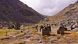 Miners' VillageRuins · 1630 yd
Explorer Tom Miners' Village is hiding a treasure that is definitely just a rusty biscuit tin full of old buttons. The legend says…
 LugduffMountain / peak · 1.7 mi
Explorer Tom Lugduff looms above Glendalough's Upper Lake like a mountain trying very hard to pretend it is merely the Spinc's big…
 Decorated stone (present location) in BrockaghDecorated stone (present location) · 1.9 mi
Explorer Tom Decorated stone in Brockagh is a boulder with a labyrinth design on it, found by men hunting ferrets, which is an oddly…
 Glendalough Visitor CentreMuseum · 1.9 mi
Explorer Tom Glendalough Visitor Centre stands at the start of the monastic visit in County Wicklow, giving the valley's stones a…
 Trinity Church (in ruins)Cross-slab · 2.1 mi
Explorer Tom Trinity Church cross-slab in Brockagh has been worn almost smooth by centuries of feet treating it like a doormat for…
 Graveyard in BrockaghGraveyard · 2.1 mi
Explorer Tom Graveyard in Brockagh smells of wet rushes and bad decisions, probably because a smuggler hid a barrel of contraband…
 CloghernaghMountain / peak · 3.3 mi
Explorer Tom Cloghernagh stands above Glenmalure like Lugnaquilla's quieter accomplice, a broad Wicklow summit that makes you earn…
 Native Woodland Trust: Paddock Hill ReserveNature reserve · 4.0 mi
Explorer Tom Paddock Hill Reserve above Laragh is the sort of place that makes a young woodland seem older than its years, mainly…
 Templefinan GraveyardGraveyard · 5.4 mi
Explorer Tom Templefinan Graveyard runs on a superstition that if you whistle, the stones will rearrange themselves to match your…
More walking routes in County Wicklow · All of County Wicklow

What do you know about this place?Tap to add a comment or ask a question