
Places near here
Photo credits
- National Inventory of Architectural Heritage
- Mike Searle, Wikimedia Commons · CC BY-SA 2.0
- Graham Horn, Geograph · CC BY-SA 2.0
- Graham Horn, Geograph · Creative Commons Attribution-ShareAlike 2.0
- Ernest Riordan, Geograph · CC BY-SA 2.0
- Jane Carver, Wikimedia Commons · CC BY-SA 2.0
- Mike Searle, Geograph · CC BY-SA 2.0
- Hywel Williams, Geograph · CC BY-SA 2.0
- Draceane, Wikimedia Commons · CC BY-SA 4.0
- Maker named on the Wikimedia Commons picture page · CC BY-SA 3.0
- Dr Brian Lynch, Geograph · CC BY-SA 2.0
 Dromore SchoolSchool · 1.8 mi
Explorer Tom Dromore School is an L-plan relic from 1886 that used to educate local kids. Now it’s just two private houses pretending to be normal. The history is thick here. Get a photo for me!
 Castle DonovanCastle · 2.0 mi
Explorer Tom Castle Donovan in County Cork was damaged by Cromwell's army back in 1650. It's on a rocky outcrop now undergoing repair. Take a photo for me if you can see the battle scars still lingering!
 Castle Donovan (in Ruins)Castle, tower house · 2.0 mi
Explorer Tom Castle Donovan in Castledonovan, County Cork is showing off its full height, despite losing a corner like it was nothing. Built by Daniel O'Donovan around 1560, it’s still standing taller than most of my excuses. Wave to the river if you can!
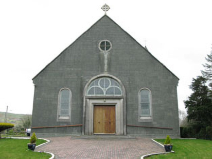 St. Joseph's Roman Catholic ChurchChurch/chapel · 2.0 mi
Explorer Tom St. Joseph's Roman Catholic Church in Dromore is the largest building in the village and sits on an elevated site. It was built to replace an earlier church, so it’s basically the big brother that took over the house. It would complain to the council about the lack of parking and the noise from the kids.
 Caheragh Burial GroundGraveyard · 3.0 mi
Explorer Tom Caheragh Burial Ground in Caheragh, County Cork sits on an east-facing slope where a medieval church used to be. The church was gone by 1699, but the graveyard stuck around. Get a photo with it before it gets a better agent and leaves town.
 Nowen Hill sw TopMountain / peak · 3.7 mi
 Nowen HillMountain / peak · 4.6 mi
 Kealkill stone circleVisitor information · 5.4 mi
 GallaunsStone circle, five-stone · 5.5 mi
Explorer Tom Gallauns in Kealkill are five stones doing a tight little circle on the bog shoulder. Go in good boots and better humour, because that bog is not your friend at all.
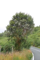 Chilean myrtle7.5 mi
Explorer Tom Chilean myrtle is here in Cork, which is like finding a parrot in a snowstorm; it’s brave but also freezing. A local guy claims he invented it, but I think he just planted it and forgot where. Take a breath of that air; it’s older than your car and smells like regret.
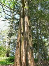 Dawn Redwood7.5 mi
Explorer Tom Dawn Redwood in Cork is keeping secrets that would make your mother-in-law blush. It says it only tells them after three pints of rainwater. Mind the nettles, they're the real security detail here and they sting.
 Ballydehob's 3-Arch Road BridgeVisitor information · 9.7 mi
More walking routes in County Cork · All of County Cork

What do you know about this place?Tap to add a comment or ask a question