DDiscover AloneMapAbout

Giants bed

Cairn, burial cairn
Computer-made picture that does not show Giants bedNot a photo of this monument
Computer-made picture. It does not show this monument. · Report the wrong picture

The monument record does not grant public access. Check the route and ask the landowner before entering private land.

What do you know about this place?Tap to add a comment or ask a question

What you write will be public.

What is recorded here

In mountainous, blanket bog-covered terrain, located on a natural elevation at the NE end of Lough Mourne. The location provides views towards Barnesmore Gap, an important natural routeway through the Blue Stack Mountains, which lies c. 5km to SE. This cairn is shown on the 1836 and 1906 OS 6-inch map as an oblong…

Read the whole record
In mountainous, blanket bog-covered terrain, located on a natural elevation at the NE end of Lough Mourne. The location provides views towards Barnesmore Gap, an important natural routeway through the Blue Stack Mountains, which lies c. 5km to SE. This cairn is shown on the 1836 and 1906 OS 6-inch map as an oblong feature named ‘Giants Bed’. A cluster of stones (DG086-002002-), shown immediately to SW of the cairn, is named ‘Stones’ on the 1836 edition and ‘Standing stones’ on the 1906 edition. When recorded by the Megalithic Survey of Ireland, the cairn appeared as a long, low, largely peat-covered mound, roughly trapezoidal in plan (25.5m NE-SW; 15m NW−SE at E, c. 8m at W), rising 0.5-1m above the surrounding boggy ground; it was interpreted as the remains of a megalithic tomb of unclassified type (Cody 2002, 63-64, no. 43). The cairn was damaged and partly robbed of stones in the past; Cody (ibid) records that ‘Thomas Fagan's account (1845-8), which includes a rudimentary sketch, describes a large disturbed cairn, at the NE end of which a pit 12 feet by 8 feet (c. 3.65m by 2.4m) and a 'few' feet deep had been dug 'in search of supposed hidden treasure' sometime before his visit there in 1846.’ In advance of the proposed construction of a dam at Lough Mourne, which will raise water levels and partly flood the area, archaeological test trenching took place at the cairn in 2010, and a programme of full excavation (licence no. 10E0309, 10R0103) followed in 2011 (Delaney 2013). Excavation revealed that the cairn consisted of an oval mound (c. 24m x c. 16m) of stones, which covered two small chambers or cists. Despite past disturbance, the cairn survived in parts to a depth of three or four courses. Its construction involved three main phases: a level foundation deposit was laid, incorporating the two cists; the foundation level was then enclosed by a stone bank defining an oval area (c. 15m x 9m), with a number of large stones placed around the base of the bank, probably functioning as a revetment; finally, the oval area was infilled with angular stones to creating the main body of the cairn. The two chambers or cists were built into the foundation deposit, and appeared to be primary features of the cairn. They were located adjacent to each other towards the SW end of the cairn. The more westerly cist (L 1.62m; Wth 1.6m; H 0.7m) was constructed on subsoil at the SW edge of the cairn, and was overlain by the stone bank defining the main body of the cairn. The NW end of this small chamber was defined by three large stones with flat internal faces; the SE end, was partly defined by a setting of smaller overlapping stones, which may have been a later modification; the cist may originally have been intended to be open to E. The floor was covered by dark brown clay, sealed by a layer of uniform small cobbles, extending out of the cist to E. Charcoal from the clay layer was identified as coming from six species, oak, willow, hazel, elm, cherry/blackthorn and birch. A charcoal sample (birch) sent for radiocarbon analysis produced a Neolithic date, 3695-3535 BC (UBA 19992). The second cist (L 2.5m; Wth 25m; H 0.6m), located 1.5m to NE, was subcircular in plan, with an opening to S. It was defined by large stones resting on subsoil, except for the W side, where a natural bedrock outcrop was utilized, and topped with small stones. Silty clay covered the floor, sealed by a deposit of small stones. Neolithic flint artefacts, including scapers, blades and flakes, were recovered from the foundation levels of the cairn, including the cists, from the enclosing stone bank and from the body of the cairn; none appeared to have been deliberately deposited: they may simply have been lost or discarded either by the cairn builders or visitors to the cairn (Delaney 2013, 9-13). Pollen analysis of a dated peat core, sampled from the vicinity of the cairn, suggests that during the Neolithic the location consisted of an exposed upland plateau, with open birch woodland, and alder around the lake shore. Blanket bog began to develop from the mid-Neolithic period onwards, and was most likely widespread by the Bronze Age (Delaney 2013, Appendix 2.4: B. Steffanini). The excavation also uncovered a complex of previously unknown monuments associated with the cairn, demonstrating that this location remained an important focus of activity from the Neolithic period to the late Bronze Age: hearths (DG086-002003-) underlying the foundation layers of the cairn indicate a phase of Neolithic activity at the site predating the construction of the cairn; a wedge tomb (DG086-002004-) was built immediately to SW of the cairn in the early Bronze Age; a pit (DG086-002006-), with associated burning, located immediately to E of the cairn, and a burnt spread (DG086-002005-) 45m to SE, dated to the middle Bronze Age, and in the late Bronze Age, a fulacht fia (DG086-002007-) was built 6m to N of the cairn. The excavator concluded that the cairn may have served as a ceremonial focal point and landmarked on an important prehistoric routeway through the Barnesmore Gap (Delaney 2013, 32). Volume VI. County Donegal. (Dublin: Stationery Office, 2002)

From the National Monuments Service (Archaeological Survey of Ireland) record DG086-002001

Places near here

Photo credits
  • Maker not stated on source page, en.wikipedia.org
  • Darrin Antrobus, Geograph · CC BY-SA 2.0
  • Maker not stated on source page, www.pinterest.com
  • Kenneth Allen, Geograph · Creative Commons Attribution-ShareAlike 2.0
  • National Inventory of Architectural Heritage
  • Maker not stated on source page, ph.pinterest.com
  • Wikimedia Commons contributor shown on the public file page · Public domain
  • Lisa Gallagher / Donegal Daily, www.donegaldaily.com
  • Kenneth Allen, Geograph · CC BY-SA 2.0
Wedge tomb in CroaghonaghWedge tomb · 12 yd

Explorer Tom Wedge tomb in Croaghonagh was only unearthing in 2011 to make room for a dam, revealing a gallery paved with white lake…

Lough HillMountain / peak · 1010 yd

Explorer Tom Right then, let’s have a look at Lough Hill in County Donegal. I spotted something white on the hill over Lough Mourne…

Wedge tomb in Meencargagh (dooish Ed)Wedge tomb · 1.4 mi

Explorer Tom Wedge tomb in Meencargagh was actually hidden under a thick coniferous forest until someone noticed it back in 1989.…

Meencarrigach National SchoolSchool · 1.5 mi

Explorer Tom Meencarrigach National School is built from such solid stone that I’m pretty sure a local legend says a giant used it…
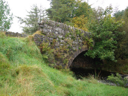
bridge1.6 mi

Explorer Tom Bridge in Croaghonagh has dressed stone voussoirs so fancy they’re basically wearing a tuxedo to a muddy field party…

Megalithic structure in LoughsallaghMegalithic structure · 1.7 mi

Explorer Tom Megalithic structure in Loughsallagh is a large slab deliberately balanced on rock, with low stones outlining a…

Megalithic tomb in CorraineMegalithic tomb · 2.0 mi

Explorer Tom Megalithic tomb in Corraine is a proper ghost story from Fagan’s notebook, back when he called it 'Grey Rocks'. No…

Old BarracksBarracks · 2.2 mi

Explorer Tom Old Barracks was built to guard Barnesmore Gap from highwaymen and brigands. It’s just fragmentary remains now, but…

Glenmore LodgeOutbuilding, walled garden, dovecote/pigeon house/aviary · 3.5 mi

Explorer Tom Glenmore Lodge is hiding a scandal so big it needs a walled garden and a dovecote to keep it secret. The main house is…

BarnesmoreMountain / peak · 3.9 mi

Explorer Tom Barnesmore has been carrying the wrong name tag. Mountaineering Ireland calls this summit Croaghonagh and says…

Páirc Thaobhóige, Glenfin GAAGAA ground · 4.8 miTeach Tábhairne an RileánPub · 5.5 mi

Explorer Tom Teach Tábhairne an Rileán in County Donegal has a mouthful of a name. Say it three times fast for me and tell me how…

More archaeology and monuments in County Donegal · All of County Donegal

Add to this placeAdd a picture Add a detailed tip Add a story

Explore the map1,095,414 places to discover

Next place · or swipeWedge tomb in Croaghonagh