
Places near here
Photo credits
- National Inventory of Architectural Heritage
- D.Camier, Wikimedia Commons · CC BY-SA 4.0
- Mick Garratt, Geograph · CC BY-SA 2.0
- Richard Webb, Geograph · CC BY-SA 2.0
- Richard Webb, Wikimedia Commons · CC BY-SA 2.0
- Graham Horn, Geograph · CC BY-SA 2.0
- Andreas F. Borchert, Wikimedia Commons · CC BY-SA 4.0
- Martin Southwood, Geograph · CC BY-SA 2.0
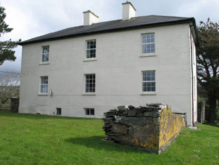 Leamcon HouseCountry house · 664 yd
Explorer Tom Leamcon House is going to bring the worst party trick of your life: a two-century-old wall that won’t budge. It’s got a hipped roof and a history of being altered, which basically means it can’t decide what it wants to be. Tell the neighbours it’s not a museum, just a really stubborn old brick.
 Signal Tower 32Signal tower · 1.1 mi
Explorer Tom Signal Tower 32 in Balteen used to watch out for French invaders back in 1796. Now it’s just a house with a flat roof and some bartizans that look like they’re trying hard. Built in 1805, it’s seen better days, I bet.
 Wedge tomb in AltarWedge tomb · 1.7 mi
Explorer Tom Wedge tomb in Altar is right by the shore, 30 meters from the rocks, looking like a giant stone sandwich left out in the rain. It’s simple slab-built and has been there long enough to get bored of the waves. Bring your worst joke, the place has heard worse.
 AltarViewpoint · 1.8 mi
Explorer Tom Altar in County Cork is where a smuggler once hid a cask of whiskey so big it needed a crane. The locals say he never got it back, and the wind still smells like regret. Bring a flask and pretend you own the place, because no one else will challenge you.
 Coney IslandIslet · 1.8 mi
Explorer Tom Coney Island in County Cork is so tiny and low-lying that a Viking got lost walking past it thinking it was just a weird rock on the beach. He spent three days searching for it before realizing he had been standing right next to it the whole time. Have a wander and a wonder.
 Long IslandIsland · 2.3 mi
Explorer Tom Long Island is almost exactly what its name promises: roughly 4.8 kilometres long and less than a kilometre wide. I appreciate that kind of honesty in an island. It lies south of Schull, with Copper Point lighthouse guarding the harbour entrance at its eastern end. Over 300 people lived here in the 1840s; abandoned cottages show how much fuller the place once was. A small permanent community remains, so this is somebody's home, not an empty stage for my explorer act. Check the current ferry timetable from Colla Pier and respect farms, gates and homes. Walk only where permitted and notice how quickly the sea appears on either side. I would claim to know every inch after one crossing, and the island would prove me wrong by lunchtime.
 Graveyard3.3 mi
Explorer Tom Graveyard in Skull sits above Schull Harbour with tons of headstones and family vaults. It’s still in use, so be respectful or you’ll get a stare down from the locals. Check the ground carefully before walking.
 Dunmanus Castle (in Ruins)Castle, tower house · 3.6 mi
Explorer Tom Dunmanus Castle is a proper four-storey beauty with a five-storey corner tower that looks like it’s shouting at the bay. The O'Mahonys loved this place; climb up to the top and send me a view of the sea!
 KnockaphucaMountain / peak · 3.8 mi
Explorer Tom Knockaphuca was where a fiddler played all night until the sun came up and he forgot to go home. The music got so good that the rocks started swaying slightly, which is still true if you touch them gently. Bring a flask and pretend you own the place; the hill doesn't care who you are.
 Dunmanus PointHeadland · 4.0 mi
Explorer Tom Dunmanus Point in County Cork was designed by a mother-in-law who liked things sharp, angular, and ready to judge your cooking from afar. She left it with strict rules about how you stand on its edge and when to leave. Tell the next person you meet it's haunted. It might be.
 Dunmanus BayBay · 4.9 mi
Explorer Tom Dunmanus Bay in County Cork thinks the road leading to it is a terrible fashion choice and needs a serious facelift before summer arrives. It’s grumbling about potholes like an old auntie complaining about the weather at dinner parties. Find the date carved somewhere and feel clever.
 Castle (in Ruins)Castle, tower house · 5.0 mi
Explorer Tom Castle on Castle Island in Roaringwater Bay is fragmentary and sits on a promontory. Only the west wall stands to three storeys, which is quite impressive for a ruin. It belonged to the O Mahony clan, so it has history!
More archaeology and monuments in County Cork · All of County Cork

What do you know about this place?Tap to add a comment or ask a question