
What is recorded here
From the National Monuments Service (Archaeological Survey of Ireland) record CO094-106
Places near here
Photo credits
- Jonathan Thacker, Geograph · Creative Commons Attribution-ShareAlike 2.0
- Maker not stated on source page, www.alamy.com
- Mike Searle, Wikimedia Commons · CC BY-SA 2.0
- Maker not stated on source page, www.pinterest.com
- National Inventory of Architectural Heritage
- Maker not stated on source page, www.dreamstime.com
- Maker not stated on source page, en.wikipedia.org
- Mike Searle, Geograph · CC BY-SA 2.0
- Maker not stated on source page, commons.wikimedia.org
 St Bartholomew's Church of Ireland ChurchChurch/chapel · 949 yd
Explorer Tom St Bartholomew's in Sleenoge has a round tower that looks like it’s been standing there since the dawn of time. The…
 Church in SleenogeChurch · 949 yd
Explorer Tom Church in Sleenoge is so mysterious right now that even the archive department has given up on uploading its details.…
 Cloigtheach (Round Tower)Round tower · 969 yd
Explorer Tom Cloigtheach in Sleenoge has a unique hexagonal base that makes it look like it was built by someone who really liked…
 Bullaun stone in SleenogeBullaun stone · 980 yd
Explorer Tom Bullaun stone in Sleenoge went missing in 2000, so it’s basically a celebrity who moved abroad and changed its name. It…
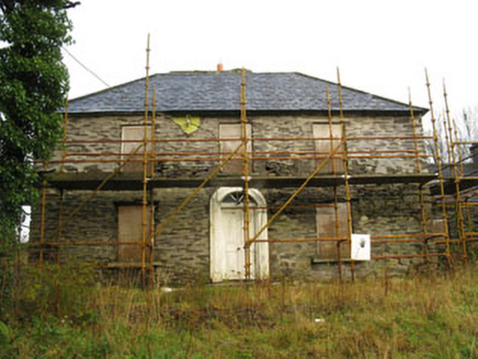 Tower ViewHouse · 1124 yd
Explorer Tom Tower View in Sleenoge is currently disused, which means it’s probably sleeping in past noon. It’s got a hipped roof…
 CastleCastle, unclassified · 1.1 mi
Explorer Tom Castle in Castletown belonged to the McCarthys of Gleannacroim before Cromwell’s soldiers torched it all down. Now…
 Fairy fort / earthen ringfort in LissacroneenFairy fort / earthen ringfort · 1.1 mi
Explorer Tom Fairy fort in Lissacroneen would have 'Lived Large' written on its tombstone, because it has managed to stay heavily…
Fairy fort / earthen ringfort in Castletown (carbery East (w.d.) By.)Fairy fort / earthen ringfort · 1.3 miExplorer Tom Castletown By.) in County Cork is acting very mysterious. The account says small upright boulders form the facing…
 Anomalous stone group in KinneighAnomalous stone group · 1.5 mi
Explorer Tom Anomalous stone group in Kinneigh is a slab supported by an upright that nobody can quite figure out. It’s near a…
 Fort RobertArchaeological place · 1.5 mi
Explorer Tom Fort Robert is an archaeological site where a prophecy said a dragon would land here in 1994, but it never did and…
 Mapped cemeteryCemetery · 1.7 mi
Explorer Tom Mapped cemetery in County Cork has a secret talent for making you feel like you’re intruding on a private conversation…
 Castle (Site of)Castle, Anglo-Norman masonry castle · 1.7 mi
Explorer Tom Castle in Castlelands (carbery East (w.d.) By.), County Cork is just a rock outcrop with a commanding view and no…
More archaeology and monuments in County Cork · All of County Cork

What do you know about this place?Tap to add a comment or ask a question