
Places near here
Photo credits
- National Inventory of Architectural Heritage
- Mike Searle, Wikimedia Commons · CC BY-SA 2.0
- Andreas F. Borchert, Wikimedia Commons · CC BY-SA 4.0
- Hywel Williams, Wikimedia Commons · CC BY-SA 2.0
- Jonathan Thacker, Geograph · CC BY-SA 2.0
- Mike Searle, Geograph · CC BY-SA 2.0
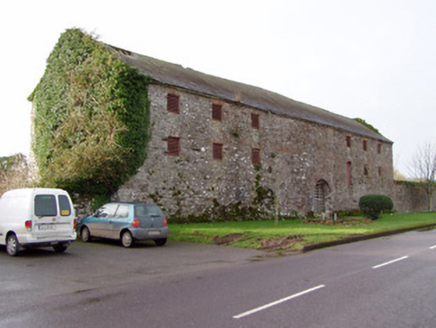 Barrymore BarnStore/warehouse · 1391 yd
Explorer Tom Barrymore Barn in Kill-St-Anne South is stuck in a fairy dispute over parking rights. Its round-headed doorways look like they’re about to argue again. It’s a massive stone structure that refuses to move. Keep your car where the fairies can’t see it!
 Barrymore Castle or Castle LyonsCastle, Anglo-Norman masonry castle · 1430 yd
Explorer Tom Barrymore Castle or Castle Lyons thinks it’s the ultimate zombie survivor, mostly because most of it has already fallen down and scattered across two separate sections. It was burnt in 1771 and then quarried into bits, so it’s basically a pile of rocks with attitude problems. Pack a picnic and an excuse for why you’re standing there looking at broken walls
 Abbey (in Ruins)Religious house, Carmelite friars · 1478 yd
Explorer Tom Abbey in Mohera is where a fox once took charge of the entire operation. The friars left and the fox moved in, so respect the hierarchy. A proper spot for a flask of tea and a big think.
 presbytery/parochial/curate's house1502 yd
Explorer Tom Presbytery in Ballyarra was built with enough render quoins to suggest the priest was counting every single cup of tea consumed during construction. The ornate porch adds a decorative focus that makes the whole thing look a bit like a fancy hat for a church. It’s part of a group with Saint Nicholas' Church, so it probably spends its days critiquing the local fashion sense.
 Holy Well1.5 mi
Explorer Tom Holy Well in Coole Upper has a concrete grotto on top of its roof. That's like putting a modern plastic toy on an ancient rock structure. Very avant-garde, I must say, though the runoff channel looks quite serious.
 Coole WellVisitor information · 1.5 mi
Explorer Tom Coole Well is dedicated to St. Devlet, who apparently had a bit of an ego and demanded his own fountain. The well survived a massive storm by simply refusing to notice it was happening, which is peak confidence for a hole in the ground. Best seen with a hangover and a sausage roll.
Pope's WellSpring · 1.6 miExplorer Tom Pope's Well would buy a private jet if it won the lotto because it’s tired of being stuck in one spot while everyone else goes on holiday. It’s quite cheeky about that, honestly, bring sandwiches, the gulls will thank you for the distraction from its existential crisis about wings.
Strawhall WoodForest · 2.9 miExplorer Tom Strawhall Wood has a shortcut that goes on for three hours and leads back to where you started, trapping people in a loop of confusion. The trees enjoy watching people give up on logic. Pack a picnic and an excuse.
Ballybrack WoodForest · 3.3 miExplorer Tom Local legend says a giant once lived in Ballybrack Wood but left because his socks didn't fit the trees properly. He took all his good luck with him, leaving us with just the bracken. Bring the dog, it'll have opinions.
 Corrin CrossMonument · 3.5 mi
Explorer Tom Corrin Cross was likely built on some incredibly shady bargain between two locals who probably owed each other money and agreed to meet here instead of going to court. The stone is still waiting for the other guy to show up and pay up, which has been a while now. Count the crows, then count again.
 Old Railway ViaductViewpoint · 4.3 mi
Explorer Tom Old Railway Viaduct has a retirement plan that involves becoming a very expensive bird feeder. It’s got iron girders and five piers that are just waiting for a nap. Bring a flask and pretend you own the place.
 Licklash Castle (in Ruins)Castle, hall-house · 4.6 mi
Explorer Tom Licklash Castle is perched on a cliff edge like it’s ready to jump ship at any moment. Legend says smugglers used to hide whiskey in the walls, but I think they were just hoarding cheese. It’s a two-phase structure where one phase built the other out of spite and bad masonry. Bring the dog, it'll have opinions.
More archaeology and monuments in County Cork · All of County Cork

What do you know about this place?Tap to add a comment or ask a question