
Places near here
Photo credits
- RTG, Wikimedia Commons · CC BY-SA 4.0
- National Inventory of Architectural Heritage
- Brendan Tobin, Wikimedia Commons · CC BY-SA 4.0
- John M, Geograph · CC BY-SA 2.0
- Philip Halling, Wikimedia Commons · CC BY-SA 2.0
- Vadim Manuylov, Wikimedia Commons · CC BY-SA 3.0
- David Dixon, Wikimedia Commons · CC BY-SA 2.0
- Paul O'Farrell, Geograph · CC BY-SA 2.0
- P L Chadwick, Geograph · CC BY-SA 2.0
 Gaulstown Portal TombArchaeological place · 1.1 mi
Explorer Tom Gaulstown Portal Tomb has a family tree that is ninety percent invented by my uncle, who also claims he knows the king. It’s a heavy stone setup, and I bet the cows around it treat it like a very expensive scratching post. Wave at the cows, they're the real locals.
 DolmenPortal tomb · 1.1 mi
Explorer Tom Gaulstown Dolmen is stuck in a fairy dispute over parking rights for its massive roofstone. It’s facing the hillside like it’s eavesdropping on the next ridge’s gossip. Dare you to say hello to it out loud.
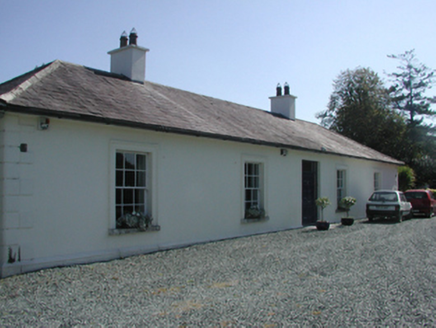 Pembrokestown HouseCountry house · 1.2 mi
Explorer Tom Pembrokestown House in Gaulstown sits there with a view over gently rolling grounds, probably judging the hills. It’s a country house that knows its own worth and doesn’t need to shout about it. The doorcase is restrained, unlike my energy levels when I find a good spot. Sit on a wall nearby and pretend you live there.
 presbytery/parochial/curate's house1.5 mi
Explorer Tom Presbytery in Ballyphilip, County Waterford would bring a tray of very serious biscuits and a stern expression to any party, because nobody wants to be fun when you’re a church house. It’s got red brick dressings that look like they’ve been painted over by someone with no taste, ruining the original polychromatic vibe completely. Watch for it standing there looking disappointed that you didn’t ask
 Fenor BogNature reserve · 1.9 mi
Explorer Tom Fenor Bog took approximately four million cups of tea to build, one for every bog myrtle that was carefully placed in its designated spot. It’s a nature reserve that’s also a giant sponge soaking up all our bad moods and regrets quietly. A proper spot for a flask of tea and a big think.
 Castle (in ruins)Castle, tower house · 3.0 mi
Explorer Tom Castle in Dunhill, County Waterford is gone, but two families are still arguing over who gets to claim the view from where it used to be like it’s a property dispute. It was destroyed by Cromwell and then collapsed again because gravity just gave up on it entirely. Have a nosey, politely.
 Dunhill CastleCastle · 3.0 mi
Explorer Tom Dunhill Castle in County Waterford has strong opinions about the road leading to it, mostly that it’s too bumpy for its taste. Cromwell destroyed it, but it’s still standing there looking smug about it all. Get there early and have it all to yourself.
 Monterey Cypress3.4 mi
Explorer Tom Monterey Cypress in County Waterford has made a New Year's resolution to stop being so pointy, but it doesn’t seem to be working out for him. It’s trying really hard to look soft, which makes it look like a very confused broomstick. Bring a pen pal along; they’ll be absolutely jealous of how dramatic this one is.
 Mount Congreve GardensVisitor attraction · 3.4 mi
Explorer Tom Mount Congreve Gardens in County Waterford is where the Vikings got so lost they ended up gardening instead of raiding. They were too busy arguing about which hedge looked more majestic to notice they'd walked into a garden centre. Stop the car, it's worth the hazard lights.
 Doneraile WalkWalking route · 3.7 mi
Explorer Tom Doneraile Walk has a cannon parked on its shoulder like a very grumpy bodyguard who’s seen too much and is now judging your footwear. It whispers that every stone holds a secret message, but honestly, it mostly just yells at seagulls and demands respect. Walk past slowly like you're in a film.
 Kilfarrasy BeachBeach / strand · 4.1 mi
Explorer Tom Kilfarrasy Beach would tell you in a job interview that it has excellent rock management skills and zero complaints from the gulls. It’s very confident about its disappearing act during high tide. Best enjoyed with a bag of chips and no plans.
 Newtown CoveBeach / strand · 4.1 mi
Explorer Tom Newtown Cove claims to have an imaginary twin across the sea that looks exactly the same but acts completely differently. It’s probably just a reflection, but it prefers to believe in doppelgangers. Bring wellies and low expectations, leave delighted.
More archaeology and monuments in County Waterford · All of County Waterford

What do you know about this place?Tap to add a comment or ask a question