
What is recorded here
Town of Portarlington was previously known as the town of Cooletodderie as mentioned in 1571 Elizabethan land grant to Owen mac Hugh O'Dempsie and described as containing 80 acres, which lieth southwest from the River of the Barough, and abutteth upon the town and lands called Bracklone East' (O'Flanagan 1933, vol. 2,…
Read the whole record
From the National Monuments Service (Archaeological Survey of Ireland) record LA005-031005
Places near here
Photo credits
- Trenchspike, Wikimedia Commons · CC BY-SA 4.0
- National Inventory of Architectural Heritage
- Mike Searle, Wikimedia Commons · CC BY-SA 2.0
- Algirdas at Lithuanian Wikipedia, Wikimedia Commons · Public domain
- Ronnie Nijboer, Wikimedia Commons · CC0
- Mike Searle, Geograph · CC BY-SA 2.0
- Garry Dickinson, Wikimedia Commons · CC BY-SA 2.0
 Saint Paul's Church (Lea)Church/chapel · 45 yd
Explorer Tom Saint Paul's Church in Cooltedery is a cruciform Gothic Revival church that might actually be built on top of an old Huguenot church from 1696. That means there’s a hidden message in the stones telling you to go away and stop touching things. The original French refugees probably didn’t expect it to become this much of a tourist trap. Mind the nettles, they're the real guards here.
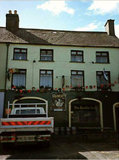 Historic buildingOfficially recorded historic building · 55 yd
Explorer Tom This Historic building in Cooltedery has a hidden treasure: definitely a biscuit tin. End-of-terrace grandeur from 1830, now a pub with commercial use on the ground floor. It’s been hiding secrets for ages. Bring a camera and your most suspicious face.
Bog Lake WalkWalking route · 1643 ydBog Oak WalkWalking route · 1.0 miBurial ground in DerryvillaBurial ground · 1.2 miExplorer Tom Burial ground in Derryvilla would describe itself as 'a hilltop with views and some bones' if it were talking to a stranger who stumbled upon it by mistake. It was uncovered during quarrying operations in 1997, so it’s had plenty of time to settle into its new life on the hill. Perfect detour when the satnav has a meltdown.
Enclosure in DerryvillaEnclosure · 1.2 miChurch (in Ruins), GraveyardChurch · 1.8 mi Lea Castle (in ruins)Castle, Anglo-Norman masonry castle · 1.8 mi
Explorer Tom Lea Castle has circular angle towers that look like they’re winking at you. A fox took charge last Tuesday and seemed to enjoy the view. Tell it a joke, it's been a long time since anyone did.
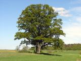 Pedunculate Oak2.3 mi
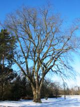 Wych Elm3.1 mi
Explorer Tom Wych Elm in County Laois is playing hide-and-seek with me. Locals swear if you tickle its trunk, it grants a wish, but only if you don't look. Dare you to say hello to it out loud?
 Emo CourtFolly · 3.2 mi
Explorer Tom The Emo Court folly is basically a fancy garden toy from the eighteenth century. When nobody’s looking, it’s probably plotting its own slow collapse into the earth. Bring your worst joke, the place has heard worse.
 Tinnakill Castle (in Ruins)Castle, tower house · 3.4 mi
More archaeology and monuments in County Laois · All of County Laois

What do you know about this place?Tap to add a comment or ask a question