
Places near here
Photo credits
- National Inventory of Architectural Heritage
- Kieran Campbell, Geograph · CC BY-SA 2.0
- Stephan van Helden, Wikimedia Commons · CC BY-SA 4.0
- Malene Thyssen, Wikimedia Commons · CC BY-SA 3.0
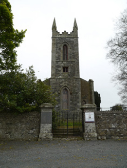 Saint Patrick's Church (Donaghmoyne)Church/chapel · 1472 yd
Explorer Tom Saint Patrick's Church (Donaghmoyne) is doing its best to look mysterious, but it’s just derelict and a bit messy. The map makers probably got confused by the rubble walls and called it 'lost'. Tell me if the gossip I'm spreading about its haunted status holds up!
 Donaghmoyne HouseGate lodge · 1560 yd
Explorer Tom Donaghmoyne House gate lodge has been refurbished so much it’s basically a new coat for an old friend. A bishop once refused to visit because he thought the arches were too showy, which was a bold move. Bring a notebook and write down how many window surrounds you can count in one minute.
 Mannan CastleArchaeological place · 1.1 miMannan Castle (in ruins)Castle, Anglo-Norman masonry castle · 1.1 mi
 Horse-chestnut1.5 miTobernagalliaghSpring · 2.1 mi
 European Beech2.2 mi
Explorer Tom This European Beech handles nosy neighbours by dropping exactly one leaf on their heads every morning as a warning. It’s subtle but deadly effective. Tell the next person you meet it's haunted. It might be.
KnockreaghMountain / peak · 4.9 miFlat cemetery in AnnaheanFlat cemetery · 5.3 miExplorer Tom Flat cemetery in Annahean is secretly proud of the bronze axe it produced. Ploughs keep finding bones here, which is mildly rude for everyone involved. Visit, then text me what you think. I'll pretend to read it.
Drumerlough MoreMountain / peak · 5.4 miMore archaeology and monuments in County Monaghan · All of County Monaghan

What do you know about this place?Tap to add a comment or ask a question