What is recorded here
From the National Monuments Service (Archaeological Survey of Ireland) record DG107-076
Places near here
Picture notes
- louise price, Wikimedia Commons · CC BY-SA 2.0
- Computer-made picture. It does not show this monument.
- National Inventory of Architectural Heritage
- Jonathan Wilkins, Wikimedia Commons · CC BY-SA 2.0
- Kenneth Allen, Geograph · CC BY-SA 2.0
- Computer-made picture. It does not show this playground.
- Jonathan Wilkins, Geograph · CC BY-SA 2.0
- N Chadwick, Geograph · CC BY-SA 2.0
- N Chadwick, Wikimedia Commons · CC BY-SA 2.0
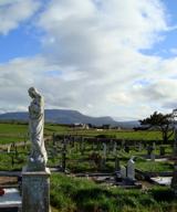 Finner Old GraveyardGraveyard · 700 yd
Explorer Tom Finner Old Graveyard is shaped like a D but apparently never finished its full circle. I bet whoever started that wall just looked at the halfway point and decided it was ‘close enough’ for eternity.
 Finner Cruciform Passage TombPassage tomb · 871 ydComputer-made picture
Explorer Tom Finner Cruciform Passage Tomb's exposed end chamber and side chambers make a cross-shaped plan. Unauthorised diggers found burnt and unburnt bone in 1955. Tom has questions, but a shovel is no way to ask them.
 Destroyed Finner Burial GroundGraveyard · 911 ydComputer-made picture
Explorer Tom Destroyed Finner Burial Ground was an oval enclosure about 130 by 90 metres, with substantial banks and a church foundation. The survey account says it was destroyed without record shortly before that account was compiled. Before then, it was probably Donegal's best-preserved example of a very rare site type. The loss is real; no bulldozer is named.
 post box1489 yd
Explorer Tom Post box in Finner is a tiny iron warrior from 1930. Made by the Carron Company, it’s got 'Post Office' raised on it but no royal cipher. It’s just sitting there on Sea Road, looking modestly important. Give it a little pat!
 Cliffs by BundoranPublicly named cliff or headland · 1541 yd
Explorer Tom Cliffs by Bundoran are right next door to a popular spot, so they might be getting a bit of tourist traffic. They’re just big rocks holding back the ocean’s ambitions. It’s a good place to stand and feel the salt spray on your face, honestly.
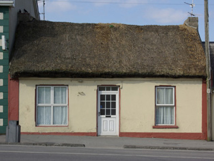 The ThatchHouse · 1646 yd
Explorer Tom The Thatch is Bundoran’s final woolly-roofed house from 1820! That huge west-end window hints it used to be a shop, so I wonder if they sold hats that fit the roof. Did customers ever get tangled in the reeds?
 The Phoenix TavernPub · 1714 yd
Explorer Tom The Phoenix Tavern in Bundoran rises from the ashes of bad decisions daily, fueled by local gossip and questionable hairdryer fumes. If you see smoke, just assume the bartender is having a moment. Bring a flask and pretend you own the place.
 mcgarriglesRestaurant · 1.1 mi
Explorer Tom Mcgarrigles is a restaurant with no capital letters, which suggests it’s very casual and probably doesn’t care about manners at all. Eat with your hands if you dare, because nobody here is going to stop you anyway. Bring curiosity, leave with a better story than mine.
 Children's playground1.2 miComputer-made picture
Explorer Tom Children's playground in County Donegal is where I left my phone and my dignity for ten solid minutes. It’s a great place to disconnect from reality and just breathe. A good place to forget your phone for ten minutes.
 Tullan StrandBeach / strand · 1.2 mi
Explorer Tom Tullan Strand gets the Atlantic swell head-on along Bundoran's north side. Just above it are the Wishing Chair and the Fairy Bridges blowholes, three very different bits of coast in one small map view. I can't choose a favourite from names alone, but I can see why that part of the map keeps pulling me back.
 BundoranOfficial bathing water · 1.2 mi
Explorer Tom Bundoran seems to have squeezed a whole seaside argument into the middle of town: rocks at either end, a sandbank that shifts with the tide, and water with its own ideas. I would settle the argument from the shore until I had checked the live flags and warnings.
 Waterworld BundoranWater park · 1.3 mi
Explorer Tom Waterworld Bundoran in County Donegal is basically a pool with attitude and a splash zone that hates your trousers. You'll come out soaked, shivering, and slightly regretful. Stand there long enough and someone will ask if you're lost.
More archaeology and monuments in County Donegal · All of County Donegal

What do you know about this place?Tap to add a comment or ask a question