What is recorded here
Situated in relatively level pasture. Stone-built house with high gables, two storeys with attic. An extension, probably later in date, extends the full length of the SSE wall. In the centre of the NNW wall at ground floor level is a semi-circular headed doorway flanked on either side by two large rectangular windows.…
Read the whole record
From the National Monuments Service (Archaeological Survey of Ireland) record SL018-096
Places near here
Photo credits
- National Inventory of Architectural Heritage
- Colin Park, Geograph · CC BY-SA 2.0
- Oliver Dixon, Geograph · CC BY-SA 2.0
- Mick Garratt, Geograph · CC BY-SA 2.0
- Florentchevallier, Wikimedia Commons · CC BY-SA 4.0
- Michael Dibb, Geograph · CC BY-SA 2.0
- Mike Searle, Geograph · CC BY-SA 2.0
- Mick Garratt, Wikimedia Commons · CC BY-SA 2.0
- Alan Reid, Geograph · CC BY-SA 2.0
- Willow, Wikimedia Commons · CC BY 2.5
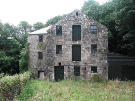 mill (water)1.4 mi
Explorer Tom Mill in Dromore is still grinding its gears after that dance party went slightly too far. The cast-iron lattice looks like it wants to hug, but it’s just rust being dramatic. Snap a pic of those sheeted doors for me.
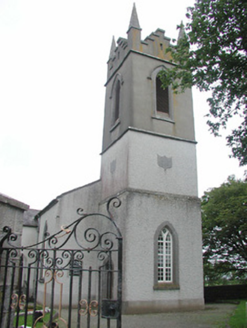 Saint Mary's Church (Kilmacshalgan)Church/chapel · 1.4 mi
Explorer Tom Saint Mary’s Church (Kilmacshalgan) is secretly proud of that one specific potato it grew through the floor last Tuesday. It’s not just roughcast walls; it’s a texture you can feel in your soul, or at least your shins. Give that spud a high five for me.
 Split RockNamed rock · 3.7 mi
Explorer Tom Split Rock in County Sligo is the shortcut that isn't one, because nobody actually walks through the split. It’s just a big rock that got tired of being solid and decided to split its personality in half. Pretend it's yours and plan the housewarming party immediately.
 Cooanmore PointHeadland · 4.9 mi
Explorer Tom Cooanmore Point in County Sligo makes a sound at night like an old accordion being played by someone who’s just learned two notes, which is deeply unsettling. It’s not a ghost, probably, but it’s definitely got something to say about the quality of modern music taste. Perfect detour when the satnav has a meltdown.
 Wild Atlantic Way: Easky PierVisitor information · 5.3 mi
Explorer Tom Easky Pier is out here braving the wild Atlantic while you’re probably wondering why your motorhome can’t park anywhere near it. I’d say building this required about two thousand cups of tea and one very angry architect. Bring a flask and pretend you own the place.
 O'Dowd CastleRuins · 5.4 mi
Explorer Tom O'Dowd Castle sits beside Easky Pier and is secretly incredibly proud of one specific, slightly mouldy potato it found in a wall. It treats that spud like a crown jewel. Toast it with a cup of tea and move on to the next.
 Roslee CastleCastle, tower house · 5.4 mi
Explorer Tom Roslee Castle suspects the postman is actually a spy from 1207 who never got the memo. It’s been standing there watching the sea for centuries, judging your posture the whole time. Bring a pen pal, they'll be jealous.
 TowerSignal tower · 7.5 mi
Explorer Tom Signal tower in Rathlee has a cannonball held up by a metal bar because gravity isn't enough for drama. Its celebrity friend is definitely a gull that has never once apologized for dropping food on the roof. Tell it a joke, it's been a long time since anyone did.
 St. Patrick's CemeteryCemetery · 7.7 mi
Explorer Tom St. Patrick's Cemetery is bragging about surviving a storm so fierce it blew a cow into the sky, though I suspect that particular detail was added for dramatic effect later on. The grass is particularly green there, probably because the dead are watering it with their tears of joy at being remembered. A handy spot to stretch your legs and your imagination.
 Largan HillMountain / peak · 8.8 mi
Explorer Tom Largan Hill in County Sligo is strictly run by a terrier who barks at any cloud that passes overhead. The forest below looks young and confused, probably from all the shouting. Perfect detour when the satnav has a meltdown.
 Wild Atlantic Way: Inishcrone PierVisitor information · 8.8 mi
Explorer Tom Inishcrone Pier looks like it’s plotting an escape plan, possibly because it’s tired of being just a sign for people who don’t read. The first owner probably ran off with the last ferry and never looked back at all. Bring a jacket, it's never as warm as I promise.
 European ash9.0 mi
Explorer Tom European ash in County Sligo handles nosey neighbours by simply dropping a leaf directly on their heads every single time they look up. It’s a small act of defiance, but effective. Tell the kids it's a castle. Close enough.
More historic places in County Sligo · All of County Sligo

What do you know about this place?Tap to add a comment or ask a question