What is recorded here
Farmyard complex in Scalkill gave its old house the sort of retirement farmers know well. A smarter house went up nearby, the old one became an outbuilding, and ‘You’ve earned a rest’ turned out to mean ‘Hold these tools.’
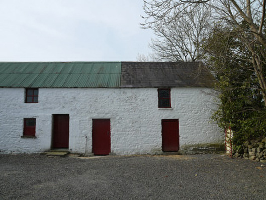
Farmyard complex consisting of attached four-bay two-storey former house, built c.1820, now in use as outbuilding, with two-bay single-storey outbuilding attached to south gable, forming west range of yard. Three-bay two-storey barn with loft forming south range of yard, built c.1870, with external shuttered concrete stairs to rear (south) elevation. Pitched corrugated-iron and slate roofs. Limewashed rubble stone walls. Square-headed openings with timber lintels, having fixed pane timber windows, timber battened shutters, and timber battened doors. Recent garage door opening to south gable of west range. Gravel surfacing to yard. Recent double-leaf gate with shuttered concrete piers to site entrance, flanked by shuttered concrete boundary walls. Stream and vegetation forming north edge of yard, with short section of dry-stone wall to north-east corner. Associated detached four-bay two-storey farmhouse, built c.1920, to south, having hipped tiled roof, red brick chimneystacks, lined-and-ruled rendered walls, and square-headed openings with recent windows and door. Wrought-iron pedestrian gate, rendered piers and boundary walls to site, latter with herringbone pattern walling.
This farm house and yard is an excellent example of a traditional farmstead arrangement, and of Ireland’s vernacular architecture in general. The former house displays many characteristics of vernacular domestic architecture including its whitewashed rubble stone walls and timber lintels, providing an interesting contrast to the more prosperous appearance of the later house nearby. The south barn was built in the late nineteenth,century and formerly had a lean-to connecting it to the earlier outbuildings to the west. The former dwelling and outbuildings have been extended and adapted overtime yet retain their character and a patina of age.
From the Buildings of Ireland (National Inventory of Architectural Heritage) record 41403008
This does not grant access. Most recorded buildings are privately owned; view them only from public ground unless the owner allows entry.
Places near here
Photo credits
- National Inventory of Architectural Heritage
- Stephan van Helden, Wikimedia Commons · CC BY-SA 4.0
- JP, Wikimedia Commons · CC BY-SA 2.0
- Oliver Dixon, Geograph · CC BY-SA 2.0
- Wanfried-Dublin, Wikimedia Commons · CC BY-SA 4.0
 farm house927 ydDrumerlough MoreMountain / peak · 1166 ydMass-rock in Camaghy,tonaneeveMass-rock · 1.1 mi
 farm house1.2 miGiants GraveArchaeological place · 2.0 miCornamaghMountain / peak · 2.3 mi
 Horse-chestnut2.5 mi
 Dún a Rí Forest ParkForest · 2.8 mi
 Fair of MuffMemorial · 3.5 mi
 Fair of MuffVisitor information · 3.5 mi
 Bush IslandIslet · 4.6 mi
 Wedge tomb in LisnadarraghWedge tomb · 5.0 mi
More historic places in County Monaghan · All of County Monaghan
What do you know about this place?