
What is recorded here
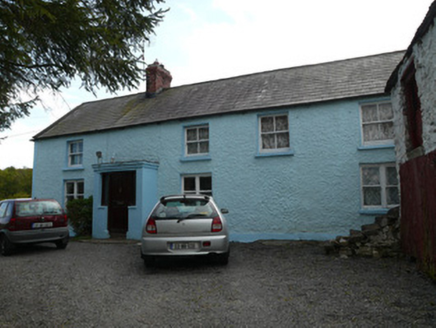
Detached three-bay two-storey farm house, built c.1800, with shallow gabled windbreak to front elevation, and having single-bay single-storey outbuilding attached to west gable, now renovated and in use as accommodation, and two-bay single-storey outbuilding to west again. Recent two-storey extension to rear. Pitched slate roof with rendered chimneystacks and cast-iron rainwater goods. Roughcast rendered walls, smooth rendered to windbreak. Square-headed window openings having timber sash windows, eight-over-eight pane to front elevation, and varied elsewhere, with fixed and pivoted widows to extension and to outbuildings. Square-headed door opening with timber half-door. Pitched slate roofs to adjoining outbuildings (to west), with stone end chimneystack, rubble stone walls with roughcast render, square-headed openings having timber windows, and timber battened door. Detached two-bay two-storey outbuilding to east having pitched slate roof, lime-washed rubble stone walls, square-headed openings and external staircase to east elevation. Evidence of former pitched-roof outbuilding against north gable. House set back from road with shallow front garden behind lime-rendered boundary walls having wrought-iron gate. Gable of outbuilding to east stands on roadside forming eastern boundary to front garden. Recent boundary wall and gate to yard east of outbuilding.
Recently sensitively renovated and extended, this house and its outbuildings retain their form and scale which contribute to its character and charm. Its form and fabric are representative of Irish vernacular farmhouses. The building footprints appears to have changed little since the early nineteenth century. Typically of vernacular farmhouses, the front elevation faces south, to benefit from the path of the sun. The small openings, simple forms, local materials, and the placing of outbuildings to the front rather than the rear of the house, are all typical of the vernacular tradition.
From the Buildings of Ireland (National Inventory of Architectural Heritage) record 41403015
This does not grant access. Most recorded buildings are privately owned; view them only from public ground unless the owner allows entry.
Places near here
Photo credits
- National Inventory of Architectural Heritage
- Oliver Dixon, Geograph · CC BY-SA 2.0
- Stephan van Helden, Wikimedia Commons · CC BY-SA 4.0
- Wanfried-Dublin, Wikimedia Commons · CC BY-SA 4.0
- Malene Thyssen, Wikimedia Commons · CC BY-SA 3.0
IndicatedFairy fort / earthen ringfort · 1358 yd farm house1.1 mifarmyard complex1.1 miRaferaghMountain / peak · 1.3 miDrumerlough MoreMountain / peak · 1.8 miGiants GraveArchaeological place · 3.2 miBush IslandIslet · 3.6 miHorse-chestnut3.7 miWedge tomb in LisnadarraghWedge tomb · 3.9 miEuropean Beech3.9 miFair of MuffMemorial · 4.5 miFair of MuffVisitor information · 4.5 mi
 farm house1.1 mi
 farmyard complex1.1 miRaferaghMountain / peak · 1.3 miDrumerlough MoreMountain / peak · 1.8 miGiants GraveArchaeological place · 3.2 mi
 Bush IslandIslet · 3.6 mi
 Horse-chestnut3.7 mi
 Wedge tomb in LisnadarraghWedge tomb · 3.9 mi
 European Beech3.9 mi
 Fair of MuffMemorial · 4.5 mi
 Fair of MuffVisitor information · 4.5 mi
More historic places in County Monaghan · All of County Monaghan
What do you know about this place?