
What is recorded here
From the National Monuments Service (Archaeological Survey of Ireland) record CO060-028
Places near here
Photo credits
- Maker not stated on source page, www.tripadvisor.com.ph
- Maker not stated on source page, mademoiselleruta.com
- Maker not stated on source page, it.pinterest.com
- Maker not stated on source page, de.wikipedia.org
- Maker not stated on source page, www.flickr.com
- Maker not stated on source page, br.pinterest.com
- Kmcnamee, Wikimedia Commons · CC BY-SA 4.0
- Sole Origami, Wikimedia Commons · CC BY-SA 4.0
- National Inventory of Architectural Heritage
- Maker not stated on source page, in.pinterest.com
 Fairy fort / earthen ringfort in Dooneens (muskerry East By.)Fairy fort / earthen ringfort · 1.0 mi
Explorer Tom Fairy fort / earthen ringfort in Dooneens is levelled but still has a slight rise in the field level. An old surveyor…
 Church (Site of)Church · 1.1 mi
Explorer Tom Church in Leadawillin is in a field named Chapel Field, next to a rock outcrop called Donnell's little rock. The site…
 Enclosure in Kilberrihert (muskerry East By.)Enclosure · 1.2 mi
Explorer Tom Enclosure in Kilberrihert sits right next to Cooper's Rock, looking like it’s waiting for a hug from its big neighbour.…
 Wedge tomb in Kilberrihert (muskerry East By.)Wedge tomb · 1.2 mi
Explorer Tom Wedge tomb in Kilberrihert sits at the foot of Cooper's Rock hill, overlooking the River Laney valley. It has a gallery…
Fairy fort / earthen ringfort in CarrigthomasFairy fort / earthen ringfort · 1.2 miExplorer Tom Fairy fort / earthen ringfort in Carrigthomas is all talk and no show, with no visible trace left on the surface. Mr.…
 Head StoneCross-slab · 1.6 mi
Explorer Tom Head Stone in Caherbaroul is a cross-slab with a Greek cross incised on it, which is fancy talk for 'it has a cross on…
 Fairy fort / earthen ringfort in CarrigagullaFairy fort / earthen ringfort · 1.6 mi
Explorer Tom Fairy fort in Carrigagulla is huge, nearly forty-two metres across. It overlooks the Laney River valley. The bank has…
Fairy fort / earthen ringfort in Kilberrihert (muskerry East By.)Fairy fort / earthen ringfort · 1.9 miExplorer Tom Fairy fort / earthen ringfort in Kilberrihert is basically an oval-shaped secret with a tunnel underneath it. Two…
 Aghinagh GAA pitchGAA ground · 1.9 mi
 St John the Baptist Roman Catholic ChurchChurch/chapel · 2.0 mi
Explorer Tom St John the Baptist Roman Catholic Church in Kilberrihert is keeping it simple and barn-like. Built around 1800, it’s…
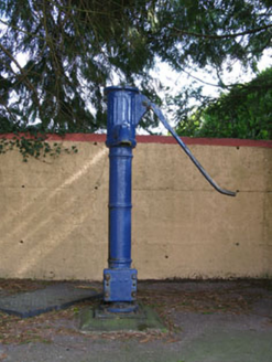 water pump2.0 mi
Explorer Tom Water pump in Rusheen lost its cap but keeps its curved handle. It’s been disused for a bit now, opposite the school.…
 Standing stone in Bawnmore (muskerry West By.)Standing stone · 2.2 mi
Explorer Tom Standing stone in Bawnmore is barely a meter high and looks more like a very upright rock that got tired of rolling…
More archaeology and monuments in County Cork · All of County Cork

What do you know about this place?Tap to add a comment or ask a question