What is recorded here
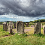
On a rise, on a terrace of rough grazing on bog, on a N-facing hillslope. An oval area (23m WSW-ENE; 18m NNW-SSE) is enclosed by leaning and largely collapsed stone slabs (up to 2m x 1m x 0.15m T) displaying traces of a wall (Wth 1.5m) consisting of an inner and outer row of contiguous slabs SW-NW. Elsewhere, a scarp…
Read the whole record
From the National Monuments Service (Archaeological Survey of Ireland) record CO119-104
Places near here
Photo credits
- Maker not stated on source page, www.connollycove.com
- Maker not stated on source page, ca.pinterest.com
- Maker not stated on source page, travelhag.com
- Maker not stated on source page, www.flickr.com
- Maker not stated on source page, www.dreamstime.com
- Maker not stated on source page, commons.wikimedia.org
- National Inventory of Architectural Heritage
- Maker not stated on source page, www.pinterest.com
- Maker not stated on source page, pixels.com
- Maker not stated on source page, www.istockphoto.com
- Draceane, Wikimedia Commons · CC BY-SA 4.0
 Standing stone in Glanbannoo UpperStanding stone · 798 yd
Explorer Tom Standing stone in Glanbannoo Upper has cup and line markings on its south-eastern side, basically ancient doodles from…
 Standing stone in GlandartStanding stone · 1539 yd
Explorer Tom Standing stone in Glandart is perched on a rocky terrace with a view across to a wooded hill. It narrows as it goes up…
 Standing stone in DrombrowStanding stone · 1.6 mi
Explorer Tom Standing stone in Drombrow is sitting dead center in a field north of the lake, looking very rectangular and dignified.…
 Bullaun stone in Dromore (carbery W. (w.d.) By.)Bullaun stone · 1.6 mi
Explorer Tom Bullaun stone in Dromore By.) was famous for curing warts with its magic water, but field clearance has now taken that…
 Standing stone in Dromore (carbery W. (w.d.) By.)Standing stone · 1.6 mi
Explorer Tom Standing stone in Dromore By.) was recorded in the nineties but has since vanished due to field clearance, which is…
 Wedge tomb in GlanatnawWedge tomb · 1.7 mi
Explorer Tom Wedge tomb in Glanatnaw is hidden under peat and heather, looking very mysterious. It’s locally called the 'Soldier's…
 Drombrow HouseCountry house · 1.8 mi
Explorer Tom Drombrow House was built in 1817 but had a fire in the mid-19th century, which Major Arthur Wilkinson fixed by…
 farm house2.2 mi
Explorer Tom Farm house in Baurgorm creaks like an old boat at night, which locals swear is the wind complaining about the rain.…
 Glanatnaw WoodWood · 2.3 mi
Explorer Tom Glanatnaw Wood has an imaginary fan club that meets every Tuesday at noon, though they’ve never actually arrived, which…
 Fairy fort / earthen ringfort in Shandrum MoreFairy fort / earthen ringfort · 2.5 mi
Explorer Tom Fairy fort / earthen ringfort in Shandrum More thinks zombies would just get lost in its shallow fosse and give up…
 Kilmocomogue GraveyardGraveyard · 3.6 mi
Explorer Tom Kilmocomogue Graveyard in County Cork is planning its retirement by turning into a very stylish garden center for the…
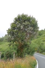 Chilean myrtle4.9 mi
Explorer Tom Chilean myrtle is here in Cork, which is like finding a parrot in a snowstorm; it’s brave but also freezing. A local…
More archaeology and monuments in County Cork · All of County Cork

What do you know about this place?Tap to add a comment or ask a question