
What is recorded here
From the National Monuments Service (Archaeological Survey of Ireland) record CO135-026
Places near here
Photo credits
- Maker not stated on source page, www.youtube.com
- Maker not stated on source page, storage.googleapis.com
- Maker not stated on source page, www.istockphoto.com
- Barraomathuna, Wikimedia Commons · CC BY-SA 4.0
- Maker not stated on source page, tr.pinterest.com
- National Inventory of Architectural Heritage
- N Chadwick, Wikimedia Commons · CC BY-SA 2.0
- Maker not stated on source page, www.irishpost.com
 Fairy fort / earthen ringfort in Grillagh (carbery East (e.d) By., Kilnagross Par.)Fairy fort / earthen ringfort · 473 yd
Explorer Tom Fairy fort / earthen ringfort in Grillagh By., Kilnagross Par.) is sitting on a slope looking vaguely disappointed…
 Standing stone (present location) in GallanesStanding stone (present location) · 662 yd
Explorer Tom This standing stone in Gallanes would review its visitors on Yelp if it could type. It’s seen some things, I promise…
 Kilnagross GraveyardGraveyard · 1266 yd
Explorer Tom Kilnagross Graveyard in County Cork would spend its lotto win on buying all the nearby hills just so it could have a…
 Kilnagross ChurchChurch/chapel · 1273 yd
Explorer Tom Kilnagross Church in Lisselane is disused since 1870. It’s a Church of Ireland building with grave markers from the…
 Church in Beanhill SouthChurch · 1274 yd
Explorer Tom Church in Beanhill South, County Cork, was built in 1821 on top of an earlier site, which is just efficient layering.…
 Lisselan HouseWalled garden · 1326 yd
Explorer Tom Lisselan House walled garden has limestone walls that are basically giant puzzle pieces. It’s got the remains of…
 bridge1353 yd
Explorer Tom Bridge in Beanhill South was part of an old railway line, so it’s got that industrial red brick look. It’s had its New…
 Clonakilty Agricultural CollegeWater tower · 1419 yd
Explorer Tom Clonakilty Agricultural College water tower is standing tall in Darrary, showing off its modern materials like a tech…
 Shannonvale MillsMill (water) · 1560 yd
Explorer Tom Shannonvale Mills in Beanhill South was a linen mill that rebels burned down, but now it grinds corn. The Earl of…
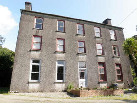 Shannonvale HouseMiller's house · 1609 yd
Explorer Tom Shannonvale House in Beanhill South was the miller’s house for the Earl of Shannon. Built around 1760, it looks down on…
 Battle of the Big Cross (1798) Memorial MonumentMonument · 1.1 mi
Explorer Tom Battle of the Big Cross (1798) Memorial Monument in County Cork is standing there looking all dignified, but I swear…
 Darrara Graveyard (Old)Graveyard · 1.2 mi
Explorer Tom Darrara Graveyard (Old) in County Cork has a hidden tunnel that allegedly goes straight to the local pub back bar. The…
More archaeology and monuments in County Cork · All of County Cork

What do you know about this place?Tap to add a comment or ask a question