What is recorded here
Situated on the SW-facing slope of a low NW-SE drumlin ridge. It is depicted as a small circular embanked enclosure on the 1834 edition of the OS 6-inch map where it is described as a ‘fort’ with field banks approaching it from NE, SE and NW. This is a circular grass-covered area (diam. 11m; 10.5m N-S;) defined by a scrub-covered earthen bank (Wth of base 2.8-3m; int. H 0.3-0.6m; ext. H 0.7m at N to 1.1m at S) with an outer fosse (at N: Wth of base 3m; ext. D 0.2m) NNW-NE that has been incorporated into a recent drain (at S: Wth of top 3m; Wth of base 1.8m; ext. D 0.6m) elsewhere . There is a large tree-stump at the centre, and there are gaps in the bank at N, E, SE and SSW, none of which need be original. The equally small enclosure (MO033-007----) is c. 100m to the ENE while the cropmark enclosure (MO033-008----) is c. 50m to the ESE.
Situated on the SW-facing slope of a low NW-SE drumlin ridge. It is depicted as a small circular embanked enclosure on the 1834 edition of the OS 6-inch map where it is described as a ‘fort’ with field banks approaching it from NE, SE and NW. This is a circular grass-covered area (diam. 11m; 10.5m N-S;) defined by a scrub-covered earthen bank (Wth of base 2.8-3m; int. H 0.3-0.6m; ext. H 0.7m at N to 1.1m at S)…
From the National Monuments Service (Archaeological Survey of Ireland) record MO033-006
The monument record does not grant public access. Check the route and ask the landowner before entering private land.
- What survives
- Recorded monument
Places near here
Enclosure in DrummondEnclosure · 131 yd lime kiln527 ydDrummond CottageFarmyard complex · 814 ydNatural Play AreaMemorial · 1.3 miCastle ruinsCastle, unclassified · 1.3 miHorse-chestnut1.4 miDún a Rí Forest ParkForest · 1.4 miCabraMountain / peak · 1.6 miDrumerlough MoreMountain / peak · 1.7 miFair of MuffMemorial · 3.9 miFair of MuffVisitor information · 3.9 miPortal tomb in ErveyPortal tomb · 4.2 mi
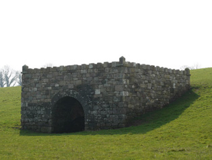 lime kiln527 yd
 Drummond CottageFarmyard complex · 814 ydNatural Play AreaMemorial · 1.3 miCastle ruinsCastle, unclassified · 1.3 mi
 Horse-chestnut1.4 mi
 Dún a Rí Forest ParkForest · 1.4 miCabraMountain / peak · 1.6 miDrumerlough MoreMountain / peak · 1.7 mi
 Fair of MuffMemorial · 3.9 mi
 Fair of MuffVisitor information · 3.9 mi
 Portal tomb in ErveyPortal tomb · 4.2 mi
Pictures: National Inventory of Architectural Heritage; Stephan van Helden, Wikimedia Commons · CC BY-SA 4.0; JP, Wikimedia Commons · CC BY-SA 2.0; Oliver Dixon, Geograph · CC BY-SA 2.0; Wanfried-Dublin, Wikimedia Commons · CC BY-SA 4.0
More archaeology and monuments in County Monaghan · All of County Monaghan
What do you know about this place?