What is recorded here
On a slight rise in bogland. Marked on OS 6-inch maps as a quadrangular enclosure (c. 35m by c. 35m): on 1st ed. there are small roughly diamond-shaped projections at E and W angles. All that survives is an irregular overgrown mound, quarried away at the centre, with a large breach at W. Possibly a moated site. II - North Galway'.
From the National Monuments Service (Archaeological Survey of Ireland) record GA072-031
The monument record does not grant public access. Check the route and ask the landowner before entering private land.
- What survives
- Recorded monument
Places near here
Photo credits
- National Inventory of Architectural Heritage
- Mikeconneely, Wikimedia Commons · CC BY-SA 4.0
- Mike Searle, Wikimedia Commons · CC BY-SA 2.0
- liam murphy, Geograph · CC BY-SA 2.0
- Andreas F. Borchert, Wikimedia Commons · CC BY-SA 4.0
- Christian Pirkl, Wikimedia Commons · CC BY-SA 3.0 at
- Miguel Angel Masegosa Martínez, Wikimedia Commons · CC BY 2.0
- ClintMalpaso, Wikimedia Commons · CC BY-SA 3.0
 kiln1.1 mi
 Saint Kerrill's National SchoolSchool · 1.4 mi
 Colmanstown HouseFarmyard complex · 1.5 mi
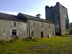 Monivea CastleCastle · 2.6 miMenlough iraMemorial · 3.7 mi
_-_geograph.org.uk_-_4069015.jpg/250px-Castles_of_Connacht,_Cashlaundarragh,_Galway_(1)_-_geograph.org.uk_-_4069015.jpg "Photo: Mike Searle, Wikimedia Commons · CC BY-SA 2.0") CashlaundarraghCastle · 4.6 mi
CashlaundarraghCastle · 4.6 mi Knockmoy AbbeyHeritage attraction · 6.9 mi
 Kilconnell AbbeyHeritage attraction · 9.3 mi
 Sycamore9.8 mi
 Sweet Chestnut9.8 mi
 St. Marys CathedralCathedral · 14 mi
 Part of St. Jarlaths CrossCross, High cross · 14 mi
More archaeology and monuments in County Galway · All of County Galway
What do you know about this place?