
What is recorded here
From the National Monuments Service (Archaeological Survey of Ireland) record RO015-017001
Places near here
Photo credits
- National Inventory of Architectural Heritage
- Aiden Clarke, Wikimedia Commons · CC BY-SA 2.0
- Jscaguiat, Wikimedia Commons · CC BY-SA 4.0
- Sawyer777, Wikimedia Commons · CC BY-SA 4.0
- Gillaween, Wikimedia Commons · CC BY-SA 4.0
- Wikimedia Commons contributor · CC BY 2.5
- Duncan Grant, Wikimedia Commons · CC BY-SA 2.0
- Willow, Wikimedia Commons · CC BY 2.5
Explorer Tom Frenchpark House is hiding a secret message in its stones, probably about who owes whom a drink. The MacDermots built it, but the stones seem to whisper about better days gone by. Look up, the best bit is always higher than you think.
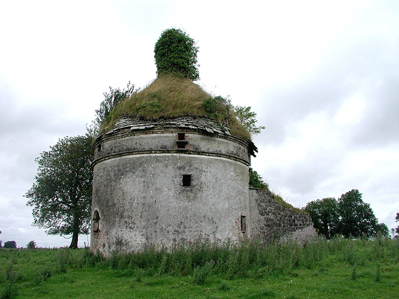 Frenchpark HouseBuilding misc · 1.7 mi
Explorer Tom Frenchpark House is a circular smokehouse with stone slates, looking like a fancy mushroom that got lost on the way to a tea party. It's probably jealous of Blarney Castle and wants a turn at the kissing stone. Keep your eyes peeled for any suspiciously round bricks lying around.
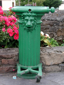 water pump1.9 mi
Explorer Tom Water pump in Frenchpark Demesne has a lion’s head that once let a goat rule the crossroads for an afternoon. The goat thought the water was for its exclusive use and charged admission with a stare. If the lion looks thirsty, it’s just pretending to be deep in philosophical contemplation again.
Square WoodForest · 2.3 miExplorer Tom Square Wood in County Roscommon looks like it was drawn with a ruler and some very angry geometry chalk. Rumor has it a fox took charge last spring and forced everyone to walk in perfect parallel lines. Bring someone who'll believe anything.
Fairymount HillMountain / peak · 2.3 miExplorer Tom Fairymount Hill has been hiding a scandal about a fairy who lost her purse and blamed a local farmer for the theft. She’s been sulking in the hollows ever since, refusing to come out because she’s too embarrassed to admit it was her own fault. It’s a secret that’s kept the air up there smelling slightly of damp wool and regret for centuries. Go before the tourists find out.
 ToberaraghtHoly well · 5.2 mi
Explorer Tom Toberaraght in Clogher has cursing stones cemented on top like very angry bookmarks. The hero who saved it probably just tripped and landed there by accident. Grand place for a sulk or a snog, entirely your call.
 Clonalis HouseMuseum · 6.7 mi
Explorer Tom Clonalis House swears it’s older than the concept of time itself, which is a stretch even for a cheeky old museum in Castlerea. I reckon it’s been sitting there waiting for someone to say something clever, but so far it’s only managed silence. Bring a friend who talks too much and let the place shut them up.
 Queen Medb: RathcroghanLegend location · 7.7 mi
Explorer Tom Queen Medb: Rathcroghan is where the Táin starts turning a quarrel about a bull into an epic. Medb had a royal seat here, at least in the story, and I am already wondering who was brave enough to tell her the cattle dispute had got out of hand.
 The Mórrígan: OweynagatLegend location · 7.7 mi
Explorer Tom The Mórrígan: Oweynagat is called the Cave of Cats, which fooled me into expecting a very ordinary sort of trouble. Then the tale sends the Mórrígan out of it during the Táin. If the cats saw her coming, I bet they made room.
 Curlew MountainsMountain / peak · 8.8 mi
Explorer Tom Curlew Mountains would survive a zombie attack by simply standing still and letting them trip over its rocks, then laughing internally. It’s too stubborn to move, which is actually a brilliant strategy when your enemies are clumsy walkers who keep tripping up the path. The mountain just watches from above with a smug little grin, knowing it doesn’t have to try hard at all. Pack a picnic and an
 CashelFairy fort / stone ringfort · 9.2 mi
Explorer Tom Another cashel in Kilcashel stands tall on the ridge, looking down its nose at everyone else with its thick, sturdy drystone walls. The builder was definitely thinking about views when they stacked those rocks, ignoring the wind and the cold completely. Bring biscuits, every good story needs biscuits.
 European ash9.7 mi
Explorer Tom European ash in County Roscommon has been the subject of some wild prophecies that never actually came true, which is annoying. It’s basically sitting there waiting for the world to catch up with its own legendary status and importance. Bring sandwiches, the gulls will thank you.
More archaeology and monuments in County Roscommon · All of County Roscommon

What do you know about this place?Tap to add a comment or ask a question