
Places near here
Photo credits
- National Inventory of Architectural Heritage
- Sawyer777, Wikimedia Commons · CC BY-SA 4.0
- Davsca at English Wikipedia, Wikimedia Commons · CC BY 3.0
- Gillaween, Wikimedia Commons · CC BY-SA 4.0
- Willow, Wikimedia Commons · CC BY 2.5
- Eric Jones, Geograph · Creative Commons Attribution-ShareAlike 2.0
- Mike Searle, Wikimedia Commons · CC BY-SA 2.0
Explorer Tom Gortnacushlaun was saved by a hero nobody remembers, who probably just kicked a boulder in the right spot. It looks like a chimney today, which is very modern for a castle. Give it a pat on the way past, it's had a long life.
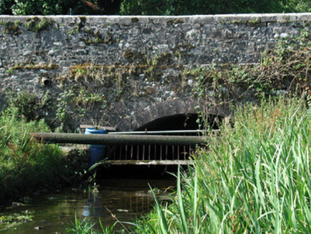 Bellanagare BridgeOfficially recorded historic building · 790 yd
Explorer Tom Bellanagare Bridge is the ultimate shortcut that isn't actually a shortcut, because every time you take it, you end up taking a different route anyway. The stonework is mixed with dressed and undressed elements, which gives it that very confused, 'I can't make up my mind' look. Cross it slowly and enjoy the scenic confusion.
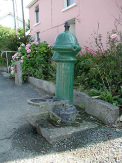 water pump962 yd
Explorer Tom The water pump in Bellanagare still works, which is impressive, considering it has had at least three different names since the last century. It has an acorn finial that looks like it belongs on a wizard's hat rather than a street fixture. Sit down nearby and let this thing amaze you with its persistence.
 Queen Medb: RathcroghanLegend location · 3.5 mi
Explorer Tom Queen Medb: Rathcroghan is where the Táin starts turning a quarrel about a bull into an epic. Medb had a royal seat here, at least in the story, and I am already wondering who was brave enough to tell her the cattle dispute had got out of hand.
 RathcroghanMound · 3.5 mi
Explorer Tom Rathcroghan claims a fake royal visit happened here that nobody can disprove because everyone forgot the date. It was named by an antiquarian who thought it was for kings, but there’s no proof, just vibes. Ten minutes here and you'll have a yarn for the pub.
 The Mórrígan: OweynagatLegend location · 3.5 mi
Explorer Tom The Mórrígan: Oweynagat is called the Cave of Cats, which fooled me into expecting a very ordinary sort of trouble. Then the tale sends the Mórrígan out of it during the Táin. If the cats saw her coming, I bet they made room.
Gray's WoodForest · 3.8 miExplorer Tom Gray's Wood in County Roscommon is in the middle of a furious dispute with a fairy over parking rights for her tiny little silver chariot lately. She’s blocking the path with her wings and he’s getting quite cross about it all, to be perfectly honest with you here. Spot the oldest stone and give it a name.
Fairymount HillMountain / peak · 4.8 miExplorer Tom Fairymount Hill has been hiding a scandal about a fairy who lost her purse and blamed a local farmer for the theft. She’s been sulking in the hollows ever since, refusing to come out because she’s too embarrassed to admit it was her own fault. It’s a secret that’s kept the air up there smelling slightly of damp wool and regret for centuries. Go before the tourists find out.
 European ash5.5 mi
Explorer Tom European ash in County Roscommon has been the subject of some wild prophecies that never actually came true, which is annoying. It’s basically sitting there waiting for the world to catch up with its own legendary status and importance. Bring sandwiches, the gulls will thank you.
ToberagullaSpring · 5.5 miExplorer Tom Toberagulla handles its nosy neighbours by just changing the colour of its water slightly whenever they get too close. It’s a subtle move, but it works every single time, and nobody can prove it otherwise. Count the crows, then count again.
 Grave YardGraveyard · 6.1 mi
Explorer Tom Graveyard in Tulsk surrounds a priory and holds fifty architectural fragments from the abbey next door. Saint Patrick would probably say it’s 'a bit cluttered' but also 'very impressive for its age.' It’s basically a junkyard of old stones with a religious twist. Go with someone who loves old stuff and watch them melt.
.jpg/250px-Castles_of_Connacht-_Ballintober,_Roscommon_(geograph_1954203).jpg "Photo: Mike Searle, Wikimedia Commons · CC BY-SA 2.0") CastleCastle, Anglo-Norman masonry castle · 8.0 mi
CastleCastle, Anglo-Norman masonry castle · 8.0 miExplorer Tom Castle in Ballintober claims a local guy invented it, which is nonsense since the Red Earl built it. But he's charming, so who am I to argue? Bring a pen pal, they'll be jealous of your tales.
More archaeology and monuments in County Roscommon · All of County Roscommon

What do you know about this place?Tap to add a comment or ask a question