
Places near here
Photo credits
- National Inventory of Architectural Heritage
- kevin higgins, Geograph · CC BY-SA 2.0
- Donald Hobern from Copenhagen, Denmark, Wikimedia Commons · CC BY 2.0
Explorer Tom Enclosure in Corrageen would say it’s a team player during a job interview, but only if you ignore its rectangular shape. It’s completely invisible on the ground, which is great for a shy introvert. Hum something sad nearby, it adds atmosphere.
Embanked enclosureEnclosure · 228 ydExplorer Tom Embanked enclosure in Corrageen, Grange Upper would be the uncle at a wedding who stole the cake and ran away. It’s gone now, but its triangular ghost still lingers on old maps. Hang around long enough and you'll hear a story from a local.
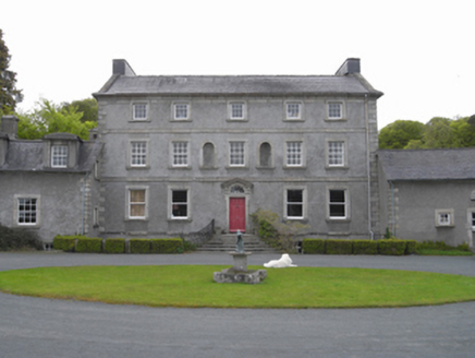 Monksgrange HouseCountry house · 756 yd
Explorer Tom Monksgrange House was built by a guy who clearly thought he was better than everyone else, and honestly? Fair point. It’s got that smug neo-Palladian vibe where every window seems to be judging your posture. I’ll take a photo if you can find me in the bushes.
 Saint Anne's Catholic ChurchChurch/chapel · 1.1 mi
Explorer Tom Saint Anne's Catholic Church in Grange Upper is doing the silent treatment when nobody’s looking at its inverted axis. It looks like a barn that went to finishing school and got slightly confused about the directions. Keep your eyes peeled for any sneaky stonework tricks nearby.
 SlievebaunMountain / peak · 1.5 mi
Explorer Tom Slievebaun is hiding a scandal involving a lost hat and a very angry vicar from 1720. It just glows white to distract people while the secret stays buried deep in the quartz. Go on, count the windows and get it wrong like I did.
1798 MemorialMemorial · 1.8 miExplorer Tom The fiddler who played here all night probably left the door open for this 1798 Memorial to join in on the tunes. It’s got that 'I’m listening' vibe, so go ahead and dare you to say hello to it out loud without getting a little chillsy feeling. Dare you to say hello to it out loud.
White MountainMountain / peak · 2.4 miExplorer Tom White Mountain once had a cow that tried to buy it with a bundle of old newspapers. The owner laughed so hard he fell off the cliff and landed in a haystack. It’s the kind of place that makes a dull Tuesday interesting.
Ruin of a small castleRuins · 3.7 miExplorer Tom This little ruin has strict rules: no touching the stones unless you plan to marry them. Nature is slowly taking it back, turning the floor into a giant mossy trampoline for local beetles. Ten minutes here and you'll have a yarn for the pub.
Coonogue WoodForest · 5.1 miExplorer Tom Coonogue Forest rests in County Carlow, and I wonder if any Ohio courthouses are secretly hiding within its branches today?
Site of Warrens CastleCastle, unclassified · 5.1 miExplorer Tom Site of Warrens Castle in Ballywilliam has an imaginary twin across the sea that keeps sending it postcards saying 'I’m doing fine over here.' It’s a faint rectangle on a map with no actual owner, which is like having a name but no address or personality. Tell it a joke, it's been a long time since anyone did.
Kilcullaun Church (in ruins), GraveyardChurch · 5.6 miExplorer Tom Kilcullaun Church, Graveyard in Tinnacarrig is indicated by a heap of masonry, which is polite for 'pile of rocks'. There’s a bullaun stone nearby, so people were probably sitting on it getting wet. Hang around long enough and you'll hear a story from a local.
 Silver Wattle5.7 mi
Explorer Tom Silver Wattle in County Carlow has strict rules: no screaming, no bad puns, and definitely no touching the bark without asking. It's all about manners out here. Stand there long enough and someone will ask if you're lost or just shy.
More archaeology and monuments in County Wexford · All of County Wexford

What do you know about this place?Tap to add a comment or ask a question