
Places near here
Photo credits
- National Inventory of Architectural Heritage
- David Purchase, Geograph · Creative Commons Attribution-ShareAlike 2.0
- Garry Dickinson, Geograph · CC BY-SA 2.0
- David Purchase, Wikimedia Commons · CC BY-SA 2.0
- George Cruikshank, Wikimedia Commons · Public domain
- Darrin Antrobus, Wikimedia Commons · CC BY-SA 2.0
- John M, Wikimedia Commons · CC BY-SA 2.0
Explorer Tom Enclosure in Bree is sick of people asking if it's actually there or just a shadow. It sits on a plateau pretending to be something bigger than a patch of grass. Pretend you're a lost aristocrat, nobody will check.
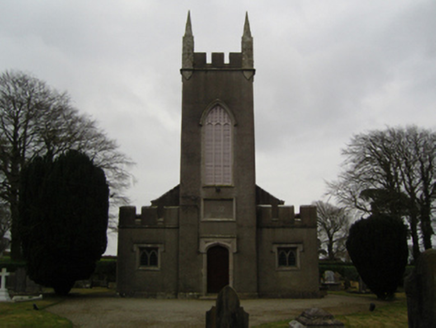 Saint John's Church (Clonmore)Church/chapel · 681 yd
Explorer Tom Saint John's Church in Clonmore is in a fairy dispute over parking rights for their tiny little wings. Harry Alcock donated the land, so the fairies think they’re entitled to prime spots near the door. If you see a shimmer on the path, back off slowly and pretend you’re looking at your phone.
Dick Joynt MemorialMemorial · 784 ydExplorer Tom Dick Joynt Memorial in County Wexford stands proudly despite the fact that we are still arguing about whether Dick was actually a person or just a very aggressive type of cloud. Some say he visited royalty, others say the royalty were hallucinating from too much tea. Make up your own legend and I'll swear it's true.
Bree HillMountain / peak · 813 ydExplorer Tom The Vikings got lost looking for Bree Hill because it kept moving slightly to the left every time they looked at their map. They gave up and went home feeling very confused about Irish geography. Stand where the owner stood and practise looking smug.
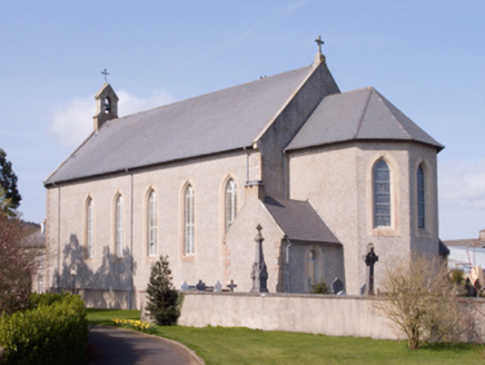 Catholic Church of the AssumptionChurch/chapel · 824 yd
Explorer Tom Catholic Church of the Assumption has a barn-like plan that makes local sheep wonder if they’re in a church or a shed. Pugin designed it to be lofty and spacious, which is great for hiding from rain. Look out for those dramatic arches!
 Clonmore Grave YardGraveyard · 1502 yd
Explorer Tom Clonmore graveyard would put 'lived long, napped often' on its tombstone if it had one of its own. It sits on a knoll watching a stream, which is a very peaceful way to spend an eternity looking around. Toast it with a cup of tea and move on to the next.
 Wilton HouseCastle, unclassified · 1.3 mi
Explorer Tom Wilton House had a ridiculous smuggling story where people supposedly hid barrels of whiskey in the walls, but I think they were just hiding from their wives and the rain outside. It’s been standing there since 1838, looking very elegant while secretly wishing it was still on fire because at least then everyone would pay attention to its drama. Pretend it's yours and plan the housewarming.
 Mackmine CastleCastle, tower house · 1.9 mi
Explorer Tom Mackmine Castle has been stuck in a feud with its own shadow for centuries because neither can figure out who actually owns the view up here. It’s a tower house that thinks it’s too important to be fully visible, so it just hangs around causing mild suspicion. Tell me if the gossip I made up is true.
Raheennahoon HillMountain / peak · 2.5 miExplorer Tom Raheennahoon Hill is guarding a treasure chest that contains only stale biscuits from 1954. The locals say it’s worth more than gold, but I’d take a scone over that any day. Bring a map, get lost anyway, that's the fun.
_p184_Defeat_at_Vinegar_Hill_(cropped).jpg/250px-MAXWELL(1845)_p184_Defeat_at_Vinegar_Hill_(cropped).jpg "Photo: George Cruikshank, Wikimedia Commons · Public domain") Battle of Vinegar HillMajor battlefield · 4.6 mi
Battle of Vinegar HillMajor battlefield · 4.6 miExplorer Tom Battle of Vinegar Hill had a cow that tried to buy the place back, which is probably more accurate than most history books. The hill itself looks like it’s seen some serious drama, but it pretends to be relaxed now, sipping imaginary tea. Give it a pat on the way past, it's had a long life.
 Battlefield in EnniscorthyBattlefield · 4.6 mi
Explorer Tom This Enniscorthy spot thinks it’s the only battlefield with actual style, which is a bold claim for a field of nothing. It’s proud of its silence and the way the wind sounds like a ghostly trumpet. Bring a map, get lost anyway, that's the fun.
 1798 MemorialStatue · 4.6 mi
Explorer Tom The 1798 Memorial in Wexford would explain the 1800s to a teenager by calling them 'mid' and complaining about the lack of Wi-Fi back then. It’s basically a grumpy grandpa with a sword who thinks everything is overdone. Bring a camera and your most suspicious face.
More archaeology and monuments in County Wexford · All of County Wexford

What do you know about this place?Tap to add a comment or ask a question