Places near here
Photo credits
- Jojo Nemčok, Wikimedia Commons · CC BY-SA 3.0
- Sarah777 at English Wikipedia, Wikimedia Commons · Public domain
- Rossyxan, Wikimedia Commons · CC BY-SA 4.0
- Wingbat, Wikimedia Commons · CC BY-SA 4.0
- National Inventory of Architectural Heritage
- Mic from Reading - Berkshire, United Kingdom, Wikimedia Commons · CC BY 2.0
- John O'Beirne, Wikimedia Commons · CC0
- Gareth James, Wikimedia Commons · CC BY-SA 2.0
- Karri Huhtanen, Wikimedia Commons · CC BY 2.0
Explorer Tom Howth Cliff Walk is incredibly proud of its ability to make your hair look like a bird’s nest in under thirty seconds. It doesn’t care about your style or your plans; it just wants to mess you up before lunch. Pop by and tell it it's looking well, even if it isn't.
Wild Rhododendron GardensWood · 510 ydExplorer Tom Wild Rhododendron Gardens does absolutely nothing when nobody is looking, except maybe argue with itself about which purple shade is the most annoying one to grow. It’s a wood that thinks it’s a fancy garden party that forgot to send out the invitations or the cake. Find the date carved somewhere in the bark and feel clever for finding it, even though
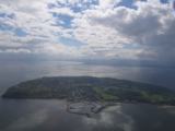 Howth HeadCoastal headland · 559 yd
Explorer Tom Howth Head in County Dublin is a massive peninsula sticking out into the Irish Sea. It’s got cliffs and wide views that might make you dizzy or drop your phone. Take a pic of the edge for me!
 Shielmartin HillMountain / peak · 567 yd
Explorer Tom Shielmartin Hill is Howth's quieter high ground, where heath and open sky take over from harbour bustle within a surprisingly short walk. Its paths have a story of their own: locals fought to keep public access across this part of the peninsula, which makes every ordinary footstep here feel like a small victory. Shielmartin sits west of the better-known Ben of Howth. Fingal County Council's study records how a landowner fenced a long-used route in the 1990s, prompting a large local walking protest and a successful court case. An alternative public right of way between Carrickbrack Road and Redrock land was agreed afterwards. That is a practical reason to stick to the recognised paths: access was won through careful work, not a licence to wander across every field. The hill is part of Howth Head's protected heathland. Fingal's management plan records dry heath here and damage from a 2021 wildfire, followed by concern about scrub spreading into the recovering ground. Look for the texture of low vegetation, not merely the view. The peninsula's slopes, Dublin Bay and the changing weather do plenty of showing off, but the heath is the fragile main act. Tom may say the gorse is plotting to reclaim his boots; it needs no help from trampling shortcuts. Fingal identifies public footpaths on Shielmartin, and its heritage study explains the Redrock connection. Use the marked or clearly established route, check current local notices and give damaged vegetation room to recover. Come for air and a view, leave with a better appreciation of the people who kept this hill walkable.
 Ben of HowthMountain / peak · 585 yd
Explorer Tom The Ben of Howth is the broad heath-covered heart of the peninsula, with Dublin Bay on one side and the Irish Sea and islands waiting when the path turns. I thought I knew Howth from the harbour; the hill politely informed me that I had only read the first page. Fingal County Council's marked walks circle the Ben after climbing the cliffs from Howth village. The Black Linn Loop crosses open hillside before returning along the former tramline, while a longer route goes beyond Red Rock and around the headland. Look for Ireland's Eye and Lambay Island in clear weather. Then turn inland and notice how quickly the busy harbour gives way to gorse, heather and a very different kind of quiet. The Ben's dry heath is part of a protected landscape. Fingal's management plan describes mature heath, scrub and some woodland on its slopes. The old Hill of Howth tram brought visitors up for views from 1901, but walkers now have the better bargain: no timetable, and considerably more freedom to stop when the sea looks particularly pleased with itself. My legs might disagree on the walk home. Choose a marked public path and check current route notices; some clifftop sections can change with erosion or works. Bring shoes for natural ground and keep well back from exposed edges. The hill is easy to underestimate because Dublin is so near, but it gives a real outing and a wide reward. By the time you return to the harbour, the boats may look smaller and your appetite much larger.
 Portal tomb in Howth DemesnePortal tomb · 643 yd
Explorer Tom Portal tomb in Howth Demesne is perched right by the golf course, watching the players miss their shots with ancient, stone-faced indifference. I claim it’s actually much older than they think, maybe built by aliens who just wanted a good view of the sea. The roofstone is huge and looks like it’s about to slide off any second now. Make a wish, it's had centuries of practice.
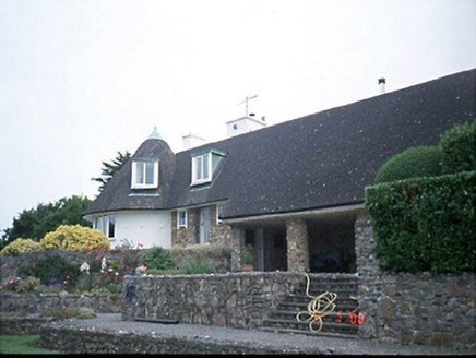 Sutton SouthHouse · 901 yd
Explorer Tom Sutton South house was Frank Gibney’s own pad from 1948, designed with Lutyens in mind. It’s got that rare integrated garden vibe and a circular plan bay that’s basically a statement piece. Check out the dormer attic for me!
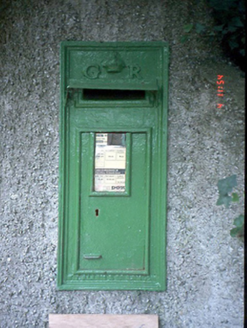 post box916 yd
Explorer Tom Post box in Sutton South was cast by T. Allen & Co. in London. It has a GR monogram and looks very British about it. But it’s in Dublin, so it’s pretending to be somewhere else.
.jpg/250px-Howth,_Co._Dublin_-_Ireland_(6858667115).jpg "Photo: Mic from Reading - Berkshire, United Kingdom, Wikimedia Commons · CC BY 2.0") National Transport MuseumMuseum · 1408 yd
National Transport MuseumMuseum · 1408 ydExplorer Tom The National Transport Museum at Howth Castle Demesne is where old working vehicles get to tell the stories that shiny new cars usually interrupt. Buses, vans, fire engines and other machines fill the Heritage Depot; I fully expect one elderly tram to demand a timetable before letting me through the door. The volunteer society behind the museum began in 1949 with an attempt to save three Dublin trams. It later became a charity and opened at Howth in 1986 after years based in County Wicklow. That beginning matters: this collection grew because people thought ordinary vehicles were worth keeping, not because anybody needed another polished royal carriage. A delivery van and a bus can explain how a city actually moved on a wet Tuesday. The museum says about sixty vehicles are on display in Howth, with others seen by prior arrangement. Its collection covers passenger, commercial, fire and emergency, military and utility transport; the oldest pieces date from the nineteenth century. Wander between different jobs rather than searching only for the biggest engine. I could make up a race between a fire engine and a bakery van, but the more interesting contest is between their very different daily duties, both now visible under one roof. This is a ticketed public museum, run by volunteers, with limited regular visiting days. Check its own current opening notice before going and allow enough time to find the Heritage Depot in the Howth demesne. The museum lists the train station within walking distance. Arrive by public transport if it suits you; that gives the collection one more journey to discuss, and perhaps keeps that bossy tram quiet.
.jpg/250px-Martello_Tower_Sutton_Dublin_(35889933420).jpg "Photo: John O'Beirne, Wikimedia Commons · CC0") Martello Tower1596 yd
Martello Tower1596 ydExplorer Tom Martello Tower in Sutton South. Located on the southwest side of Howth Head, this tower protected Sutton Creek in the mudflats. The masonry has been recorded as part of the north Dublin towers. A guardian of the muddy shallows.
 St Mary's AbbeyGraveyard · 1642 yd
Explorer Tom St Mary's Abbey in County Dublin has this secret talent for making you feel incredibly small and slightly guilty about your phone usage while you stand there pretending to be spiritual. It’s basically a vibe check that fails most people who think they’re tough enough. Find a local and ask them the real story, then come back and tell me.
 Corr CastleCastle, tower house · 1.2 mi
Explorer Tom Corr Castle in Howth Demesne is a three-storey tower house with a turret that probably has the best view of the garden party. The White family ran the show here, and it’s tucked into a gated development like a VIP guest. Spot the oldest stone and give it a name.
More archaeology and monuments in County Dublin · All of County Dublin

What do you know about this place?Tap to add a comment or ask a question