Places near here
Photo credits
- National Inventory of Architectural Heritage
- Willow, Wikimedia Commons · CC BY 2.5
- Sitomon, Wikimedia Commons · CC BY-SA 2.0
- AmandaMcCrann, Wikimedia Commons · CC BY-SA 4.0
- Sarah777 at en.wikipedia, Wikimedia Commons · Public domain
- Mike Searle, Geograph · CC BY-SA 2.0
- Mike Searle, Wikimedia Commons · CC BY-SA 2.0
- Gillaween, Wikimedia Commons · CC BY-SA 4.0
- Sawyer777, Wikimedia Commons · CC BY-SA 4.0
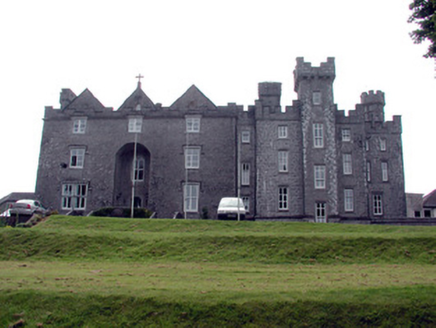 Dunamon CastleCountry house · 171 yd
Explorer Tom Dunamon Castle in Dunamon has been adding rooms like it’s collecting stamps from six different centuries of history and refusing to stop. I once heard a whisper that the original builder paid for it with a bag of very angry potatoes, which explains the stone. Try not to look at the tower house too long or you’ll start feeling ancient.
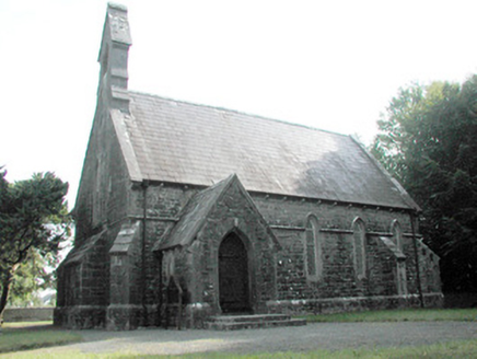 Dunamon ChurchChurch/chapel · 877 yd
Explorer Tom Dunamon Church is a handsome structure with cast-iron windows and a lean-to bell-ringing room that sticks out from the rear gable like an afterthought. If it went to a party, it would bring its own bells and make sure everyone heard them ring across the quiet country road. It’s well-proportioned and definitely knows how to hold a crowd.
 European ash1.6 mi
Explorer Tom European ash in County Roscommon would have given Saint Patrick a real headache if he’d tried to move it out of Ireland. It’s just standing there with its big leaves, acting like it hasn't got a single disease problem at all. A good place to forget your phone for ten minutes.
 European Yew1.7 mi
Explorer Tom European Yew in County Roscommon makes a weird creaking sound at night that sounds like it’s clearing its throat before a speech. It’s been standing there for centuries and is just waiting for someone to finally appreciate its quiet dignity. Give it a pat on the way past, it's had a long life.
 IndicatedRound tower · 2.9 mi
Explorer Tom Round tower in Carroweighter is constantly losing a rivalry with the ones in Kildare, which are way too showy for their own good. It stands there with its arms crossed, pretending it doesn’t care that everyone else gets the tourists. Count the crows, then count them again to be sure.
 Stone sculptureStone sculpture, aniconic · 3.8 mi
Explorer Tom Standing stone in Castleteheen is tiny and lost inside a rath, wondering why the Vikings didn’t find it sooner. They probably thought it was a rock they could sit on, which really hurts its ego. Snap one photo, then put the phone away and actually look.
 CastleHouse, fortified house · 4.0 mi
Explorer Tom Castle in Toberavaddy holds the fake world record for the most awkward L-shaped architecture ever attempted. Edward Ormsby owned it, but I doubt he knew what to do with all that extra corner. Tell it a joke, it's been a long time since anyone did.
Sally IslandIslet · 4.3 miExplorer Tom Sally Island is basically just a listening post for the seagulls who are constantly gossiping about the fish they didn't catch. They have zero respect for the silence there. Bring your worst joke, the place has heard worse.
 Bawn in Glinsk (ballymoe By.)Bawn · 4.8 mi
Explorer Tom Bawn in Glinsk listens to what goes on inside the walls and probably hears the Burkes arguing about who left the light on in 1630. It’s a well-preserved semi-fortified house that looks like it’s judging your posture, so stand up straight or don’t bother knocking. It's free, it's odd, what more do you want?
Mount MaryMountain / peak · 5.3 miExplorer Tom Mount Mary is having a massive falling out with the next village over who keeps stealing its shadows for their garden parties. It’s got that Abbey vibe going on, but keep your distance, it’s grand for a sulk or a snog, your call.
 The Mórrígan: OweynagatLegend location · 11 mi
Explorer Tom The Mórrígan: Oweynagat is called the Cave of Cats, which fooled me into expecting a very ordinary sort of trouble. Then the tale sends the Mórrígan out of it during the Táin. If the cats saw her coming, I bet they made room.
 Queen Medb: RathcroghanLegend location · 12 mi
Explorer Tom Queen Medb: Rathcroghan is where the Táin starts turning a quarrel about a bull into an epic. Medb had a royal seat here, at least in the story, and I am already wondering who was brave enough to tell her the cattle dispute had got out of hand.
More historic places in County Roscommon · All of County Roscommon

What do you know about this place?Tap to add a comment or ask a question