
Places near here
Photo credits
- Sarah777 at en.wikipedia, Wikimedia Commons · Public domain
- National Inventory of Architectural Heritage
- Kk, Wikimedia Commons · CC0
- Sitomon, Wikimedia Commons · CC BY-SA 2.0
- AmandaMcCrann, Wikimedia Commons · CC BY-SA 4.0
- Irishrover1980, Wikimedia Commons · CC BY-SA 4.0
- dougf, Geograph · CC BY-SA 2.0
- Mike Searle, Wikimedia Commons · CC BY-SA 2.0
- Gillaween, Wikimedia Commons · CC BY-SA 4.0
- Sawyer777, Wikimedia Commons · CC BY-SA 4.0
- Peter Allen, Wikimedia Commons · CC BY-SA 2.0
 Stone sculptureStone sculpture, aniconic · 978 yd
Explorer Tom Standing stone in Castleteheen is tiny and lost inside a rath, wondering why the Vikings didn’t find it sooner. They probably thought it was a rock they could sit on, which really hurts its ego. Snap one photo, then put the phone away and actually look.
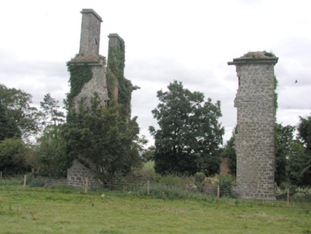 CastlestrangeFarmyard complex · 1090 yd
Explorer Tom Castlestrange farmyard complex is currently engaged in a fierce staring contest with the nearest tree, neither of them willing to blink first. The ruined house looks totally unbothered by this whole dramatic mess. Point your phone at the carriage arch and see if it flinches for you.
 Rookwood BridgeBridge · 1581 yd
Explorer Tom Rookwood Bridge has cutwaters so big they could park a car in, but its refuges are shallow as a puddle in summer. It handles nosey neighbours by simply letting them get stuck on the arches. Bring a flask of something strong to calm your nerves.
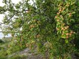 European Crab Apple2.3 mi
Explorer Tom European Crab Apple in County Roscommon claims to be three hundred years old, but I think it’s just lying to get more attention from tourists. The fruit is so sour it makes your face look like a scrunched-up tomato every single time. Ideal stop for a big stretch and a bigger yawn.
 European Yew2.5 mi
Explorer Tom European Yew in County Roscommon would bring a bottle of poison and a smile to any party it ever attended. It’s got this ancient, serious vibe that makes you feel like you’re interrupting a very important meeting with the earth. Hang around long enough and you'll hear a story from a local.
 Kellys MonumentMonumental structure · 4.9 mi
Explorer Tom Kellys Monument in Killeroran is a round tower that gave up its height for Lent and decided to lie down flat and take a nap forever. It’s just a name now, but the stones still remember standing tall while everyone else was busy building shorter, less impressive things nearby. Ideal for a moody photo you'll pretend wasn't posed.
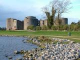 Roscommon CastleCastle · 5.2 mi
Explorer Tom Roscommon Castle in County Roscommon would explain the 1800s to a teenager by saying, 'Imagine your mum's house, but with more damp and fewer Wi-Fi signals.' It’s been sitting there judging everyone since before we had proper trousers, still looking mighty smug about it. Go now, before it gets famous.
 CastleCastle, tower house · 5.4 mi
Explorer Tom Castle in Cloghan is hiding a treasure that is definitely a biscuit tin from the seventies, but I'm not taking questions. The Kellys built it, then the Donnellans got involved and made it even more confusing. Stand where the owner stood and practise looking smug.
 Bawn in Glinsk (ballymoe By.)Bawn · 7.9 mi
Explorer Tom Bawn in Glinsk listens to what goes on inside the walls and probably hears the Burkes arguing about who left the light on in 1630. It’s a well-preserved semi-fortified house that looks like it’s judging your posture, so stand up straight or don’t bother knocking. It's free, it's odd, what more do you want?
 The Mórrígan: OweynagatLegend location · 15 mi
Explorer Tom The Mórrígan: Oweynagat is called the Cave of Cats, which fooled me into expecting a very ordinary sort of trouble. Then the tale sends the Mórrígan out of it during the Táin. If the cats saw her coming, I bet they made room.
 Queen Medb: RathcroghanLegend location · 15 mi
Explorer Tom Queen Medb: Rathcroghan is where the Táin starts turning a quarrel about a bull into an epic. Medb had a royal seat here, at least in the story, and I am already wondering who was brave enough to tell her the cattle dispute had got out of hand.
 Kilconnell AbbeyVisitor attraction · 18 mi
Explorer Tom Kilconnell Abbey would take its lotto win and spend it all on a really fancy hat for one of the statues just to see if anyone notices. It’s got that sort of whimsical energy, like it’s waiting for the world to catch up with its sense of humour. Mind the nettles, they're the real guards here.
More castles and forts in County Roscommon · All of County Roscommon

What do you know about this place?Tap to add a comment or ask a question