What is recorded here
Internal diam. 22m. A circular area enclosed by a collapsed stone wall in which some stretches of original wall facing are visi-ble. 6m to 9m from the wall a second line of stones may have been an outer wall or revetment. In places the original inner wall width can be seen to have been 3m. Modern field walls have been…
Read the whole record
From the National Monuments Service (Archaeological Survey of Ireland) record DG016-011
Places near here
Picture notes
- Rossographer, Geograph · CC BY-SA 2.0
- Computer-made picture. It does not show this monument.
- National Inventory of Architectural Heritage
- Anne Burgess, Wikimedia Commons · CC BY-SA 2.0
- Computer-made picture. It does not show this playground.
- Computer-made picture. It does not show this mountain top.
 DowningsOfficial bathing water · 377 yd
Explorer Tom Downings gets to sit snug in Sheephaven Bay while Rosguill takes the Atlantic full in the face. I can almost hear the peninsula boasting about the arrangement. Donegal tourism lists windsurfing here, though the wind gets the final say on any plans for the water.
 McNutts Coffee HouseCafé · 378 yd
Explorer Tom McNutts Coffee House might be vacant, but McNutts of Downings are still trading around the corner as a woollen mill. Take a pic of the empty room and tell them Tom was there, looking suspiciously confused by the silence. Bring a camera and your most suspicious face.
Beach HotelHotel · 879 ydExplorer Tom Beach Hotel in County Donegal is right by the beach, which means sand everywhere, including in places you didn't know existed. Pack a vacuum cleaner just to be safe. Pretend you're a lost aristocrat, nobody will check your papers here.
 Hut site in Leargain RiachHut site · 1091 ydComputer-made picture
Explorer Tom Hut site in Leargain Riach is a subcircular foundation inside a ruined stone enclosure on a rocky knoll. The survey measured the smaller foundation at about 3.5 metres across. With an older wall and a newer field wall nearby, the plan has layers; the people who made them are unnamed.
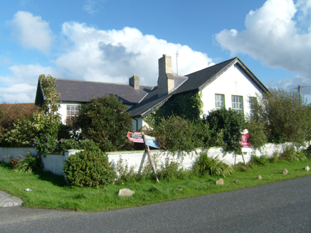 Scoil Náisiúnta Doire Chasáin [Derrycassan National School]School · 1212 yd
Explorer Tom Scoil Náisiúnta Doire Chasáin is a former national school from 1902 that has swapped chalkboards for carpets. Those original timber sliding sash windows still stare out from what is now a private dwelling, looking slightly confused about the change of curriculum.
 Cliffs at Lamb's IslandPublicly named cliff or headland · 1351 yd
Explorer Tom Cliffs at Lamb's Island are exactly what they say: rocky drops near an island that might not even have any sheep on it. The birds probably rule the roost there. Keep your footing secure and try not to scare the gulls off their lunch spots.
 Cliffs north of DowniesPublicly named cliff or headland · 1378 yd
Explorer Tom Cliffs north of Downies are just cliffs, but they look like they’ve seen some things. The name 'Downies' makes me think of sheep, so I’m expecting them any minute now. Ten minutes here and you'll have a yarn for the pub.
 Children's playground1632 ydComputer-made picture
Explorer Tom This playground is definitely judging your life choices, just like Tom does. The sandbox might be full of ancient treasure if you dig deep enough. Bring a jacket, it's never as warm as I promise.
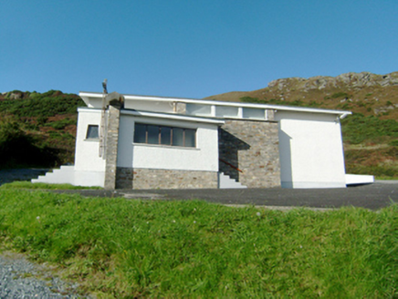 Stella Maris Catholic ChurchChurch/chapel · 1.0 mi
Explorer Tom Stella Maris Catholic Church in Magherabeg is keeping things simple with those square-headed windows. It was built in 1954 to look modern, which back then meant looking like a slightly confused filing cabinet, but I dig the clean lines anyway.
 Midden in Machaire LoisctheMidden · 1.0 miComputer-made picture
Explorer Tom Midden in Machaire Loiscthe is a pile of ancient kitchen scraps that has vanished from the grassy sand dunes by Sheephaven Bay. They took photos back in the early twentieth century, but now the mounds are gone. I suspect the gulls just couldn't resist helping themselves.
 Gáinne MórMountain / peak · 1.2 miComputer-made picture
Explorer Tom Gáinne Mór is a mountain peak in County Donegal that keeps its access details firmly under wraps. The name sounds like a sneeze trapped in a woolly hat, so I suspect the summit is just holding its breath to see if anyone dares to climb it anyway.
 Clonmass IslandIslet · 1.8 mi
Explorer Tom Clonmass Island is sitting quietly in Clonmass Bay, probably judging your life choices from afar in County Donegal. Bring a flask of something warm and a story to swap, because I've run out of my own stories already.
More archaeology and monuments in County Donegal · All of County Donegal

What do you know about this place?Tap to add a comment or ask a question