What is recorded here
From OpenStreetMap (© OpenStreetMap contributors) n332373598
Places near here
Photo credits
- National Inventory of Architectural Heritage
- Andreas F. Borchert, Wikimedia Commons · CC BY-SA 4.0
- Rossographer, Geograph · CC BY-SA 2.0
- John M, Geograph · CC BY-SA 2.0
- Anne Burgess, Wikimedia Commons · CC BY-SA 2.0
- Patrice78500, Wikimedia Commons · CC BY-SA 3.0
- Kieran Evans, Wikimedia Commons · CC BY-SA 4.0
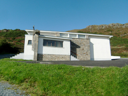 Stella Maris Catholic ChurchChurch/chapel · 389 yd
Explorer Tom Stella Maris Catholic Church, built in 1954, stands with a rubble sandstone panel on its south face.
 Mevagh High CrossCross, High cross · 1109 yd
Explorer Tom Mevagh High Cross is a stark, undecorated slab standing in the graveyard of a ruined medieval church. It’s simple and unadorned, which makes it feel like a quiet guardian overlooking the steep drop to Mulroy Bay. No fancy patterns here, just raw stone and history.
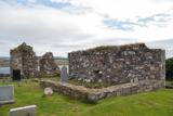 Mevagh Old ChurchChurch · 1109 yd
Explorer Tom Mevagh Old Church was called an ancient ruined parish church in a 1622 record. The later survey describes parts of its east and west gables and south wall; near one corner lay a separate stone with twenty-three cup marks. I followed the church outline in the record and found another question beside it.
 Beach HotelHotel · 1647 yd
Explorer Tom Beach Hotel in County Donegal is right by the beach, which means sand everywhere, including in places you didn't know existed. Pack a vacuum cleaner just to be safe.
DowningsOfficial bathing water · 1.2 miExplorer Tom Downings gets to sit snug in Sheephaven Bay while Rosguill takes the Atlantic full in the face. I can almost hear the peninsula boasting about the arrangement. Donegal tourism lists windsurfing here, though the wind gets the final say on any plans for the water.
 McNutts Coffee HouseCafé · 1.3 mi
Explorer Tom McNutts Coffee House in County Donegal might be vacant! If so, take a pic of the empty room and tell them Tom was there!
 Rosses StrandBeach / strand · 1.5 mi
Explorer Tom Rosses Strand has a classic sound to it, promising gentle waves and wide spaces for exploration along the Donegal coast.
 Cliffs at Lamb's IslandPublicly named cliff or headland · 1.7 mi
Explorer Tom Cliffs at Lamb's Island stand tall and proud, guarding the waters around this small Donegal island with rocky grace.
 Cliffs on Ros GuillPublicly named cliff or headland · 1.7 mi
Explorer Tom Ros Guill’s cliffs probably see their fair share of wind, so keep your hat on and watch where you step!
 Cnoc na SleáMountain / peak · 2.0 mi
Explorer Tom Cnoc na Sleá means 'hill of the spear', though I would leave any spear firmly in the name. The guide also calls this small Donegal hill Crocknasleigh and points out its older Irish spelling. One hill, two ways to say it, and a very pointed name.
 The Murder HoleCave · 2.3 mi
Explorer Tom The Murder Hole cave hints at darker history on its beach, though the name may simply be a local ghost story.
 Clonmass IslandIslet · 3.0 mi
Explorer Tom Clonmass Island sits near Little Isle at the north of Clonmass Bay, a place where accurate maps are essential for finding your way.
More mountains and hills in County Donegal · All of County Donegal

What do you know about this place?Tap to add a comment or ask a question