Places near here
Photo credits
- National Inventory of Architectural Heritage
- Kenneth Allen, Geograph · Creative Commons Attribution-ShareAlike 2.0
- Wanfried-Dublin, Wikimedia Commons · CC BY 4.0
- Enda O Flaherty, Wikimedia Commons · CC BY-SA 2.0
- This file is from the Mechanical Curator collection , a set of over 1 million images scanned from out-of-copyright books and released to Flickr Commons by the British Library. View image on Flickr View all images from book View catalogue entry for book ., Wikimedia Commons · Public domain
- D Gore, Geograph · CC BY-SA 2.0
- Oliver Dixon, Geograph · CC BY-SA 2.0
 bridge209 yd
Explorer Tom Bridge in Derryvally is a railway bridge from 1855 that stopped carrying trains in 1959 but kept its elegance. It’s got rusticated stone voussoirs that make the arch look like it’s smiling. The bridge survived the end of the line, which is a bit like an old friend who stays after the party. Pass under it and marvel at the stonework without checking for trains.
 First Ballybay Presbyterian ChurchChurch/chapel · 232 yd
Explorer Tom First Ballybay Presbyterian Church in Derryvally is playing hide-and-seek with me. It sits an Irish mile away because the law said so, which makes total sense if you squint hard enough. It’s the kind of place that whispers secrets.
 Derryvally Presbyterian ChurchChurch/chapel · 250 yd
Explorer Tom Derryvally Presbyterian Church held a dance that went so far the floor caught fire, allegedly. It was built in 1800 after a massive argument about a minister appointment. Look serious, nod slowly, and leave before they ask you to stay.
 Derryvally National SchoolSchool · 267 yd
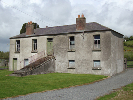
Explorer Tom Derryvally National School in Derryvally has a local who claims to have invented the word 'school'. It closed down years ago but still acts like it’s running things. Stand there long enough and you might hear echoes.
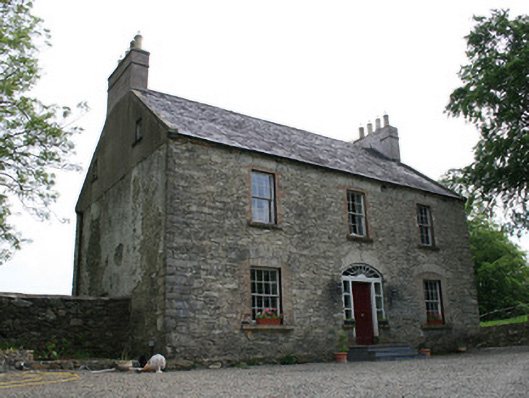
 HillcrestHouse · 447 yd
Explorer Tom Hillcrest in Derryvally is sitting on its hill acting like it owns the Ballybay to Newblies view, which it probably does. It’s got those elegant classical proportions that scream 'I was built before smartphones were just shiny rocks.' The stone steps leading up look like they’ve been waiting for a grand entrance since the late 1700s. Don’t trip on them; the house will notice.
 CrystalbrookHouse · 1086 yd
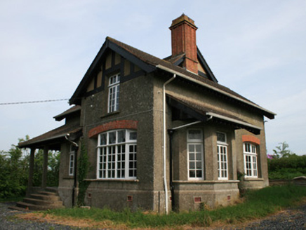
Explorer Tom Crystalbrook in Monantin is an Arts-and-Crafts house that really leaned into the whole 'handmade and fancy' vibe back at the turn of the century. It has those intricate windows and chimneys that make it look like a fairytale character's home, but with better insulation. It's definitely showing off its architectural muscles from across the road. Try not to stare too long.
Ballybay Wetland CentreNature reserve · 1122 ydExplorer Tom Ballybay Wetland Centre had a poet fall in the ditch nearby, who then wrote a sonnet about mud that was surprisingly accurate and deeply unpleasant. It’s a spot that probably still has the smell of wet earth and ambition mixed together. Bring a flask and pretend you own the place.
 Portal tomb in LennanPortal tomb · 3.2 mi
Explorer Tom Portal tomb in Lennan is perched on a drumlin ridge, looking slightly tipsy from the wind. If it could order at a chipper, it’d just want a stone and some silence. Stand on the spot and imagine the gossip it's heard.
 Giants GreveWedge tomb · 5.3 mi
Explorer Tom "Giants Greve is hiding a scandal about a stone that wasn’t invited to the party. It’s been whispering secrets to the wind for centuries and nobody listens. Snap one photo, then put the phone away and actually look."
 Dartrey ForestForest · 5.8 mi
Explorer Tom Dartrey Forest used to have a great house at its centre, and the trees have done a fine job of carrying on without it. The Dawson family's Dartrey House was demolished in 1946. Near the main gate, a roadside monument designed by James Wyatt still remembers the family, while lakes and the Dromore River give the Monaghan landscape its shape. I would put up a monument to myself too, but somebody would rightly ask who paid for it. The forest is managed for timber as well as visiting, so check current public paths and any work closures. Keep to permitted routes and leave the old wall and monuments alone. Look across the linked water from a safe trail. The missing house is one story; the living woods have plenty of their own.
 Flagpole HillMountain / peak · 6.3 mi
Explorer Tom Flagpole Hill is the sort of peak that clearly had a mother-in-law design it, giving it that distinct look of permanent, passive-aggressive disappointment. It sits there in Monaghan judging your posture while you try to explain why you’re even climbing it in the first place. Stick around for the light changing, it's a show.
 Bush IslandIslet · 9.2 mi
Explorer Tom Bush Island would survive a zombie attack by just being too small for them to bother with. It’s basically an impenetrable fortress of pure indifference and moss. Pop by and tell it it's looking well.
More historic places in County Monaghan · All of County Monaghan

What do you know about this place?Tap to add a comment or ask a question