
What is recorded here
From OpenStreetMap (© OpenStreetMap contributors) n9331491832
Places near here
Photo credits
- Royalcanalrunner, Wikimedia Commons · CC BY-SA 4.0
- Maker not stated on source page, voyage.supersportgeo.de
- Stephan van Helden, Wikimedia Commons · CC BY-SA 4.0
- Maker not stated on source page, www.flickr.com
- Robin Pollard, Wikimedia Commons · CC BY 3.0
- Maker not stated on source page, commons.wikimedia.org
- Maker not stated on source page, en.wikipedia.org
- Maker not stated on source page, www.geograph.ie
- Picture: AllTrippers / Tiqets
- Maker not stated on source page, uk.pinterest.com
- Maker not stated on source page, au.pinterest.com
 Ticknevin LockLock · 1056 yd
Explorer Tom Ticknevin Lock was born from a pub bet about who could move the most water. It’s a civil engineering masterpiece that…
 CastleCastle, unclassified · 1107 yd
Explorer Tom Castle in Ticknevin is a roofless tower that probably just wanted a snack but got stuck in the middle of the field…
 Ticknevin BridgeBridge · 1383 yd
Explorer Tom Ticknevin Bridge has an elegant arch that makes me want to bow to it, yet some bishop refused to even glance its way.…
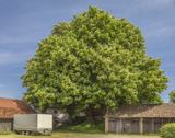 Horse-chestnut1.8 mi
Explorer Tom Horse-chestnut drops stones that are secretly messages from the future if you squint really hard at them. No one reads…
 Holy well in DerrinturnHoly well · 2.1 mi
Explorer Tom Trinity Well in Demesne is where the River Boyne starts its big journey. A priest once lost a bet here and never spoke…
 Catholic Church of the Holy TrinityChurch/chapel · 2.2 mi
Explorer Tom Catholic Church of the Holy Trinity in Derrinturn has a superstition that if you count the windows, you’ll be stuck…
 Site of CastleCastle, unclassified · 2.2 mi
Explorer Tom Site of Castle at Clonkeen refuses to fall down because it has an ego issue. It’s been sitting there smugly since the…
 Fairy fort / ringfort in ClonkeenFairy fort / ringfort · 2.4 mi
Explorer Tom Fairy fort / ringfort in Clonkeen is a forty-metre circle that would cope terribly on a reality show because it has no…
 Cross-inscribed stone (present location) in Lullymore WestCross-inscribed stone (present location) · 2.7 mi
Explorer Tom Cross-inscribed stone in Lullymore West would win a county fair with its double-ring design. It’s sitting in a museum…
 Lullymore Heritage ParkHeritage attraction · 3.1 mi
Explorer Tom Lullymore Heritage and Discovery Park sits on a mineral island in Kildare's Bog of Allen, which sounds like where a…
 Holy well in Lullymore EastHoly well · 3.3 mi
Explorer Tom Holy well in Lullymore East is making a spooky gurgling sound at midnight, or so I hear. It vanished from sight but the…
 Crosspatrick GraveyardGraveyard · 6.2 mi
Explorer Tom Crosspatrick Graveyard was nearly sold to a farmer for the price of a single horse back in the day, but the deal fell…
More mountains and hills in County Kildare · All of County Kildare

What do you know about this place?Tap to add a comment or ask a question