What is recorded here
From the Irish Caves Database, University of Bristol Spelæological Society record 1527
Places near here
Picture notes
- Computer-made picture. It does not show this monument.
- Computer-made picture. It does not show this mountain top.
- The Banner, Wikimedia Commons · CC BY-SA 3.0
- Computer-made picture. It does not show this playground.
- National Inventory of Architectural Heritage
- P.hammer, Wikimedia Commons · CC BY-SA 3.0
- Gareth James, Geograph · CC BY-SA 2.0
- No machine-readable author provided. Bogman assumed (based on copyright claims)., Wikimedia Commons · CC BY 2.5
- Bob Jones, Geograph · CC BY-SA 2.0
 KnockaunacrogheraBarrow, unclassified · 738 ydComputer-made picture
Explorer Tom Knockaunacroghera is top of the hill, which sounds grand until you realise it might just be where some Spaniards got very lost in 1588. A dance went wrong there centuries ago, and nobody has recovered from it yet. Linger, it's not going anywhere and neither should you.
 Fairy fort / earthen ringfort in GortaclobFairy fort / earthen ringfort · 853 ydComputer-made picture
Explorer Tom Fairy fort / earthen ringfort in Gortaclob sits on a boggy rise, which means if you slip, you're joining the locals permanently. It's got wide views except for the bit where it gets high ground. Perfect detour when the satnav has a meltdown.
 KnockacarnMountain / peak · 870 ydComputer-made picture
Explorer Tom Knockacarn is a rugged presence in the hills, its summit marked by the enduring strength of the land it guards.
 Catholic Church of the Holy RosaryChurch/chapel · 966 yd
Explorer Tom In Ballyvoe, the Holy Rosary church from 1820 wears a trefoil opening above its door. Its paired lancet windows suggest a history of community gathering and prayer.
 Children's playground1246 ydComputer-made picture
Explorer Tom A children's playground that’s filled with activity and the sounds of laughter in County Clare.
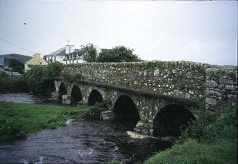 Roadford BridgeBridge · 1612 yd
Explorer Tom Roadford Bridge has six arches, which is a lot of effort for something you just walk across. Built in 1810, it’s probably tired of carrying cars instead of horses. Bring your worst joke, the place has heard worse from drunk farmers since the Victorian era.
 Doolin CaveCave · 1.1 mi
Explorer Tom Doolin Cave stands proud in County Clare, and I can practically hear the sea echoing off its stone walls.
 Doonmacfelim Castle (in Ruins)Castle, tower house · 1.5 mi
Explorer Tom Doonmacfelim Castle was built on a mound because the builder had zero imagination. It changed hands so often it probably forgot its own name. Stand where the owner stood and practise looking smug.
 Ballinalacken CastleCastle · 1.5 mi
Explorer Tom Ballinalacken Castle is a two-stage towerhouse near Doolin, standing as a silent witness to centuries of history in County Clare.
 Wild Atlantic Way: Doolin PierVisitor information · 2.2 mi
Explorer Tom Wild Atlantic Way: Doolin Pier has me imagining a place where the pier is as long as the tide
 Doolin PointHeadland · 2.3 mi
Explorer Tom Doolin Point features a limestone platform in County Clare, where Atlantic waves crash energetically against the rock face.
 Ballaghaline PointHeadland · 2.4 mi
Explorer Tom Ballaghaline Point looks out toward Crab Island and Inisheer from this headland, framing a lovely view across the water.
More caves in County Clare · All of County Clare

What do you know about this place?Tap to add a comment or ask a question