
What is recorded here
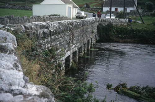
Six-arch rubble stone road bridge over river, built c. 1810, with cut-stone voussoirs and cutwaters.
From the Buildings of Ireland (National Inventory of Architectural Heritage) record 20400821
This does not grant access. Most recorded buildings are privately owned; view them only from public ground unless the owner allows entry.
Places near here
Enclosure in Ballycahan,killilaghEnclosure · 538 yd bridge562 ydFisherstreet PotCave · 746 ydCatholic Church of the Holy RosaryChurch/chapel · 929 ydDoonmacfelim Castle (in Ruins)Castle, tower house · 1046 ydCourt tomb in TeergoneanCourt tomb · 1.0 miDoonagore Castle in ruinsCastle, tower house · 1.2 miWild Atlantic Way: Doolin PierVisitor information · 1.4 miDoolin PointHeadland · 1.5 miBallaghaline PointHeadland · 1.5 miCrab IslandIslet · 1.7 miDoolin CaveCave · 1.9 mi
 bridge562 ydFisherstreet PotCave · 746 yd
 Catholic Church of the Holy RosaryChurch/chapel · 929 yd
 Doonmacfelim Castle (in Ruins)Castle, tower house · 1046 yd
 Court tomb in TeergoneanCourt tomb · 1.0 mi
 Doonagore Castle in ruinsCastle, tower house · 1.2 mi
 Wild Atlantic Way: Doolin PierVisitor information · 1.4 mi
 Doolin PointHeadland · 1.5 mi
 Ballaghaline PointHeadland · 1.5 mi
 Crab IslandIslet · 1.7 mi
 Doolin CaveCave · 1.9 mi
Pictures: National Inventory of Architectural Heritage; The Banner, Wikimedia Commons · CC BY-SA 3.0; Gareth James, Geograph · CC BY-SA 2.0; No machine-readable author provided. Bogman assumed (based on copyright claims)., Wikimedia Commons · CC BY-SA 2.5; Valfex, Wikimedia Commons · CC BY-SA 3.0; Bob Jones, Geograph · CC BY-SA 2.0; Gordon Hatton, Geograph · CC BY-SA 2.0; P.hammer, Wikimedia Commons · CC BY-SA 3.0
More historic places in County Clare · All of County Clare
What do you know about this place?