What is recorded here
From OpenStreetMap (© OpenStreetMap contributors) n3804704366
Places near here
Photo credits
- Kenneth Allen, Wikimedia Commons · CC BY-SA 2.0
- Robert Bone, Wikimedia Commons · CC BY-SA 2.0
- John Cromie, Geograph · CC BY-SA 2.0
- National Inventory of Architectural Heritage
- Eric Jones, Geograph · CC BY-SA 2.0
- louise price, Wikimedia Commons · CC BY-SA 2.0
- Kenneth Allen, Geograph · CC BY-SA 2.0
- Ronnie Nijboer, Wikimedia Commons · CC0
 Stone cairn, LougherrigPublicly named cairn · 976 yd
Explorer Tom A stone cairn at Lougherrig, captured in photos though its exact age remains unproven by this public record.
 Giant's Grave Megalithic TombMegalithic tomb · 1.3 mi
Explorer Tom Giant's Grave Megalithic Tomb lies deep in boggy ground between Aghla and Scraigs. The recorded gallery was five metres long, with six stones on each side. A slab across one end might not have been part of its original roof. That uncertainty is more interesting than pretending the wet ground offers an easy look inside.
 Aghla MountainMountain / peak · 1.5 mi
Explorer Tom Aghla Mountain is a majestic peak in County Donegal, standing tall against the sky and inviting adventurers to test their skills on its rugged slopes.
 Aghla Mountain South TopMountain / peak · 1.7 mi
Explorer Tom Aghla Mountain South Top only shows its face on all-too-rare days when it isn't shrouded in damp mist. I suppose the mountain prefers its curtains drawn most of the time.
 lime kiln1.8 mi
Explorer Tom Lime kiln in Meentymorgal was built c.1880 with an earth embankment behind it for loading crushed limestone. I reckon that huge pile of dirt was basically a giant slide, but made of mud and rocks, waiting for someone to push a wheelbarrow down it.
 Graffy BridgeBridge · 3.3 mi
Explorer Tom Graffy Bridge was built around 1830 with two arches over the Stracashel River and an additional arch to the southwest. Cut-stone triangular cutwaters face the flow. I thought the bridge had finished its sentence after two arches; the third adds a cheeky postscript.
 Gweebarra BarPub · 5.9 mi
Explorer Tom Gweebarra Bar sits on a sharp bend in the N56, waiting for someone to drift into it. Snap a shot and don't let the road win!
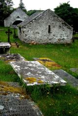 Inishkeel Graveyard near GlentiesGraveyard · 6.2 mi
Explorer Tom Inishkeel Graveyard near Glenties was rectangular in the older survey, but its south side sat on part of a roughly circular rise. Some of that rise lay beyond the west wall, about fifty metres across. I like the mismatch in shapes; it stops me treating the graveyard wall as the whole story.
 Kennedy's Bar and RestaurantRestaurant · 6.2 mi
Explorer Tom Kennedy's Bar and Restaurant is definitely hiding a secret menu involving only cabbage and regret. I bet the barman knows more about ghosts than he does about cocktails, so keep your ears peeled for whispers while you eat.
 St. Connell's Museum and Heritage CentreMuseum · 6.3 mi
Explorer Tom St. Connell's Museum and Heritage Centre lets me go from an old courtroom to the cells below, then into stories of the workhouse and Donegal railways. That is a lot of Glenties history packed into one building. I would leave the cells to the displays and keep my own visit on the friendly side of the door.
 Wych Elm6.8 mi
Explorer Tom Another fine Wych Elm awaits in County Donegal, so remember to check if you need permission first.
 Disert GraveyardGraveyard · 8.7 mi
Explorer Tom Disert Graveyard is a D-shaped pocket inside two larger enclosures, with at least 34 low uninscribed grave markers noted across its centre. The account also records a striking custom: people took soil from near the altar because it was reputed to drive rats from houses. I'd keep that as a belief people held, not a promise from the place.
More mountains and hills in County Donegal · All of County Donegal

What do you know about this place?Tap to add a comment or ask a question