
What is recorded here
From OpenStreetMap (© OpenStreetMap contributors) n332373273
Places near here
Photo credits
- National Inventory of Architectural Heritage
- Maker not stated on source page, www.travelingwithmj.com
- Kieran Evans, Wikimedia Commons · CC BY-SA 2.0
- Maker not stated on source page, commons.wikimedia.org
- John Cromie, Wikimedia Commons · CC BY-SA 2.0
- John Cromie, Geograph · CC BY-SA 2.0
- Robert Bone, Wikimedia Commons · CC BY-SA 2.0
- Richard Webb, Wikimedia Commons · CC BY-SA 2.0
- louise price, Wikimedia Commons · CC BY-SA 2.0
 Catholic Church of the Holy FamilyChurch/chapel · 1.3 mi
Explorer Tom Catholic Church of the Holy Family dates to 1906 and has a four-petal shape set inside a circle above its porch. The…
 Fairy fort / earthen ringfort in An Tseanga Mheáin (tc An Ghrafaidh)Fairy fort / earthen ringfort · 1.9 mi
Explorer Tom Fairy fort / earthen ringfort in An Tseanga Mheáin has a bank standing over two metres high on the north side. It’s a…
 Lavagh MoreMountain / peak · 2.0 mi
Explorer Tom Lavagh More is involved in a feud with its neighbour over who owns the best view of the sunset, which has been going on…
 Graffy BridgeBridge · 2.1 mi
Explorer Tom Graffy Bridge was built around 1830 with two arches over the Stracashel River and an additional arch to the southwest.…
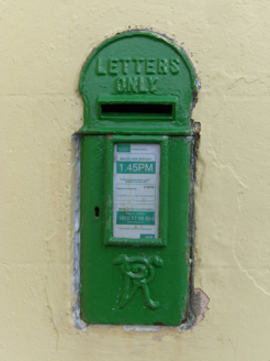 post box2.5 mi
Explorer Tom Post box in Greenans, installed c.1870, keeps its raised VR lettering firmly planted at the bottom. It sits right in…
 McDevitt's BridgeBridge · 2.5 mi
Explorer Tom McDevitt's Bridge, built c.1780, crosses the Owenea River on three segmental arches. Those cut-stone triangular…
 Burial ground in Lag Na GaileadhBurial ground · 2.8 mi
Explorer Tom The Burial ground in Lag Na Gaileadh is a quiet oval mound on the bank of the Owenea river. It holds a stone slab with…
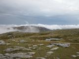 CroaghgormMountain / peak · 3.1 mi
Explorer Tom Croaghgorm is the high head of Donegal's Bluestack Mountains, 674 metres above the fuss below. Its Irish name means…
 Aghla Mountain South TopMountain / peak · 3.3 mi
Explorer Tom Aghla Mountain South Top in Donegal claims there’s a shortcut, but it’s really just a fancy way of saying 'good luck…
 Aghla MountainMountain / peak · 3.5 mi
Explorer Tom Aghla Mountain would want 'Finally Rested' on its tombstone because it’s been holding up the sky for way too long…
 ArdnageerMountain / peak · 3.7 mi
Explorer Tom Ardnageer is the main event here, and it knows it, standing tall while its little sibling plays second fiddle down the…
 Disert GraveyardGraveyard · 4.5 mi
Explorer Tom Disert Graveyard is a D-shaped pocket inside two larger enclosures, with at least 34 low uninscribed grave markers…
More mountains and hills in County Donegal · All of County Donegal

What do you know about this place?Tap to add a comment or ask a question