
Places near here
Photo credits
- David Dixon, Geograph · CC BY-SA 2.0
- Michael Dibb, Wikimedia Commons · CC BY-SA 2.0
- Michael Dibb, Geograph · Creative Commons Attribution-ShareAlike 2.0
- michael clarke stuff, Wikimedia Commons · CC BY-SA 2.0
- Corinna Schleiffer, Geograph Ireland via Wikimedia Commons
- Wanfried-Dublin, Wikimedia Commons · CC BY-SA 4.0
- Kenneth Allen, Geograph · CC BY-SA 2.0
- Corinna Schleiffer, Geograph · CC BY-SA 2.0
- Dr Neil Clifton, Geograph · CC BY-SA 2.0
- Andreas F. Borchert, Wikimedia Commons · CC BY-SA 4.0
- N Chadwick, Geograph · CC BY-SA 2.0
- Dr Neil Clifton, Wikimedia Commons · CC BY-SA 2.0
 Church (in Ruins)Church · 11 yd
Explorer Tom Church in Lag left a right angle of old masonry beside the modern church when surveyed. A small stone cross stood north of it, while a hexagonal font outside the modern door was believed to have come from Fahan. Three pieces, three different stories; I would not roll that travelled font into the lost church's walls.
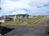 Lag GraveyardGraveyard · 17 yd
Explorer Tom Lag Graveyard lies in a natural enclosure of sandhills north of the Trawbreaga Bay channel. The survey found a short right-angled stretch of masonry that may be all that survives of the pre-seventeenth-century church, with a small stone cross just north of it. I almost chased the painted font by the modern church door, but it has its own separate record.
 St. Mary's Catholic ChurchChurch/chapel · 23 yd
Explorer Tom Step into the grounds of St. Mary's Catholic Church in Lag, built back in 1784 and reportedly the first chapel of its kind in Inishowen. The T-shaped plan might look a bit odd at first, but it’s actually a later adaptation from after Catholic Emancipation, so keep your eyes peeled for those early 18th-century gravemarkers while you’re here.
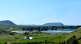 Five Finger StrandBeach / strand · 793 yd
Explorer Tom Five Finger Strand is all wild sand dunes and rocky fingers reaching out like a desperate hand for help. It’s the kind of place that makes you feel tiny and gloriously unimportant. Bring a pen pal, they'll be jealous.
 Doagh Famine VillageMuseum · 1720 yd
Explorer Tom Doagh Famine Village tells this coast's history through homes, voices and a guided tour. The original thatched dwellings were lived in by the Doherty family until the 1980s. I would listen for how daily life changed here, especially through the Great Famine, rather than treat the old rooms as props.
 Magheranaul Wedge TombWedge tomb · 1.9 mi
Explorer Tom Magheranaul Wedge Tomb has a single roofstone covering its gallery, with an hour-glass hole bored right through the closing stone. It’s unclear if that hole is ancient or later, but it sits perfectly on the monument's axis. A real head-scratcher hidden in the pasture.
 Bawn in CarrickabraghyBawn · 1.9 mi
Explorer Tom Bawn in Carrickabraghy has a rare witness in writing: a Plantation-era account says Lieutenant Hoan had finished a lime-and-stone bawn while bound to rebuild the castle. The castle stood on a seashore promontory. I would like to match that old sentence to the broken walls, without giving every surviving stone to Hoan.
 Carrickabraghy CastleCastle · 1.9 mi
Explorer Tom Carrickabraghy Castle sits on a rock where the Atlantic probably splashes right up its nose. I bet a Viking once stood there, held his shield high, and shouted 'we live here now' while trying not to slip on the wet stones.
 White StrandGuesthouse · 2.3 mi
Explorer Tom White Strand is probably white because it hasn't been cleaned since 1954, or maybe it’s just naturally that pristine. The guesthouse beds are likely made with feathers that belong to very angry geese who demand respect in return. Bring a map, get lost anyway, that's the fun.
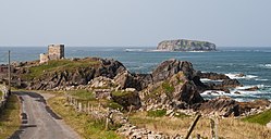 Glashedy IslandIslet · 2.9 mi
Explorer Tom Glashedy Island is chilling next to Carrickabraghy Castle, probably mocking its grandeur from across the water. It looks like it took a nap and forgot to wake up. Best enjoyed with a bag of chips and no plans.

 E. McCleanRestaurant · 3.1 mi
Explorer Tom E. McClean is a great restaurant now, with lunch or dinner worth turning up for. Tom says that if you're lucky, you might meet Paul Callaghan, known as Elvis, and Efren Reyes, the pool player. He's bringing an appetite and keeping an eye out.
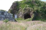 Wee House of Malin CaveCave · 3.2 mi
Explorer Tom Wee House of Malin Cave is measured at only 2.75 metres deep, yet the local saying gives it room for everything that goes in. That is one ambitious little house. The recorded cave sits beside Malin Well and the old church; I would let the story stretch the walls while leaving the real rock alone.
More archaeology and monuments in County Donegal · All of County Donegal

What do you know about this place?Tap to add a comment or ask a question