Places near here
Photo credits
- National Inventory of Architectural Heritage
- BrendanLacey72, Wikimedia Commons · CC BY-SA 4.0
- P L Chadwick, Wikimedia Commons · CC BY-SA 2.0
- Colin Park, Geograph · CC BY-SA 2.0
- Stephan van Helden, Wikimedia Commons · CC BY-SA 4.0
- Slamforeman, Wikimedia Commons · CC BY 4.0
- Oliver Dixon, Geograph · CC BY-SA 2.0
- Hywel Williams, Wikimedia Commons · CC BY-SA 2.0
- Mike Searle, Wikimedia Commons · CC BY-SA 2.0
- Taken by Fanghong, Wikimedia Commons · CC BY-SA 3.0
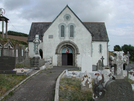 Saint Gobnait's Catholic ChurchChurch/chapel · 1157 yd
Explorer Tom Saint Gobnait's Catholic Church (Kilgobnet) would cope on a reality show by hiding in its cruciform shadow and refusing to eat until someone apologized for touching its roof. It was built for Reverend Richard O'Gorman by Walter Glynn Doolin, so it’s got serious ecclesiastical muscle and a very strong sense of self-preservation. If you see the church shifting slightly to avoid a camera crew, that’s
 farm house1352 yd
Explorer Tom Farm house in Kilgobnet is playing hard to get. My mate says a giant once tried to carry it off, but his knees buckled under the weight of all that limewashed stone. He’s still stuck there, just staring at the doorcase, looking properly confused about why nobody wants him back.
 Master McGrathMemorial · 1.2 mi
Explorer Tom The shortcut near Master McGrath is definitely not a shortcut; it’s just a very long walk with extra steps. But the legend says if you run fast enough, you can catch your own shadow. Have a nosey, politely.
 Walton ParkPark · 2.8 mi
Explorer Tom Walton Park in County Waterford treats every nosy neighbour like a pesky fly that just won’t stop buzzing around its head, swatting them away with aggressive shrubs and suspicious silence. It’s the kind of garden that pretends not to hear you while secretly judging your footwear for an hour. Mind those nettles, because they are definitely the real guards here.
 Grattan SquareVisitor information · 2.9 mi
Explorer Tom Grattan Square would say in a job interview that its main strength is 'holding space' and its weakness is 'pigeon droppings.' It’s just a square in Dungarvan with a big ego about being the center of town life. It thinks every conversation happening on its benches is a state secret it needs to protect. Bring your worst joke, the place has heard worse.
 Horse-chestnut2.9 mi
Explorer Tom Horse-chestnut in County Waterford is sick of being asked if its fruits are actually edible, especially when they taste like disappointment. It just wants people to appreciate the shape of it instead of trying to eat it. It's the kind of place that makes a dull Tuesday interesting.
 Waterford County MuseumMuseum · 3.0 mi
Explorer Tom Waterford County Museum has misplaced its sense of direction and ended up parked next to a chip shop by pure accident. I’m telling you, the exhibits are probably hiding behind the tea urn because they’re shy about being so local. Go at sunset and thank me later.
 Dungarvan Castle (in Ruins)Castle, Anglo-Norman masonry castle · 3.0 mi
Explorer Tom Dungarvan Castle in Dungarvan is secretly proud of a potato that grew inside its wall in 1902 and was eaten by a soldier who didn’t even leave a thank-you note. It’s been a barracks, a prison, and now just a very tired building looking at the water. Snap one photo, then put the phone away and actually look.
 Cunnigar PointHeadland · 3.4 mi
Explorer Tom Cunnigar Point really dislikes when tourists try to take selfies with their backs turned. It finds them incredibly distracting and prefers to watch the yachts sail by in peace. Ideal for a moody photo you'll pretend wasn't posed.
 Battle of AffaneMajor battlefield · 7.6 mi
Explorer Tom Battle of Affane is where two earls argued over money until everyone ended up in the mud, which sounds like a lot of family dinners I’ve been to. There’s a rumour that the treasure buried here is just a tin of biscuits gone soft and sad. Have a sandwich here and call it a heritage lunch.
 Tourin CastleCastle, tower house · 8.6 mi
Explorer Tom Tourin Castle hides a treasure chest that is definitely just a biscuit tin and some old keys left behind by a confused tenant. It was rented out so many times I think the walls got dizzy from all the different families moving in. Bring your nan, she'll know more than me.
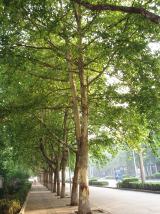 London Plane8.6 mi
Explorer Tom London Plane in County Waterford must have been thinking about lunch when they planted this one, given how perfectly positioned it is for a break. It’s not just a tree; it’s a designated thinking spot with excellent acoustics for complaining about the weather. Grab your flask of tea and have a proper big think out there.
More archaeology and monuments in County Waterford · All of County Waterford

What do you know about this place?Tap to add a comment or ask a question