
Places near here
Photo credits
- N Chadwick, Wikimedia Commons · CC BY-SA 2.0
- National Inventory of Architectural Heritage
- N Chadwick, Geograph · CC BY-SA 2.0
- Chris Gunns, Geograph · CC BY-SA 2.0
- Colin Park, Wikimedia Commons · CC BY-SA 2.0
- David Baird, Wikimedia Commons · CC BY-SA 2.0
- C Michael Hogan, Wikimedia Commons · CC BY-SA 2.0
- Kenneth Allen, Geograph · CC BY-SA 2.0
- Rossographer, Geograph · CC BY-SA 2.0
- Ross, Wikimedia Commons · CC BY-SA 2.0
 Cairn, Coastguard HillPublicly named cairn · 433 yd
Explorer Tom Cairn, Coastguard Hill is a place where the name itself tells you it’s on a hill with a view of the sea. I imagine standing there and seeing how far out the water goes, which would have been perfect for spotting ships or just enjoying the wind. It’s one of those spots that feels like it was chosen for its vantage point.
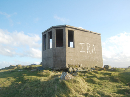 Horn Head Lookout PostWatch tower, signal tower · 444 yd
Explorer Tom Horn Head Lookout Post was built by the Irish Army during World War Two to watch for submarines. It’s just a small hut, but it kept an eye on G2 intelligence back then. That is one dedicated little building. Find this unassuming structure at the north end and see if any soldiers are still hiding inside!
 Coastguard HillMountain / peak · 457 yd
Explorer Tom Coastguard Hill in County Donegal is technically run by a very aggressive terrier who thinks he’s the head of security for the whole coastline. He barks at seagulls with such conviction that you’d believe he was guarding the Crown Jewels rather than some grassy slope. Hum something sad nearby, it adds atmosphere.
 CrocksheeMountain / peak · 818 yd
Explorer Tom Crockshee sits in County Donegal, and the map record is as bare-bones as a mountain can be. The picture caption notes it’s visible from Coastguard Hill, three kilometres from Dunfanaghy, which makes me wonder if it’s just standing there, quietly judging my hiking boots.
 Horn Head Signal TowerRuins · 1203 yd
Explorer Tom Horn Head Signal Tower is listed as a ruin, which feels like a dramatic understatement for a structure that has simply stopped trying. I am genuinely puzzled by how it managed to survive long enough to become properly derelict without anyone noticing the whole thing was quietly giving up.
 Cliffs at Traghlisk PointPublicly named cliff or headland · 1371 yd
Explorer Tom Cliffs at Traghlisk Point are in a lifelong feud with the rain because it keeps trying to wash away their sense of dignity while they just stand there getting soaked and grumpy about it. The cliffs win on durability but lose on style every single time the weather decides to have its fun at their expense. Bring a coin for luck and keep it in your pocket.
 Horn HeadCoast · 1416 yd
Explorer Tom Horn Head seems determined to show off both sides of the coast: Sheephaven Bay one way, Atlantic cliffs the other. Even the road winds around for an encore. Discover Ireland says the cliffside is open and unprotected, so I would keep my clever remarks well back from the edge.
 Horn Head Portal TombPortal tomb · 1.1 mi
Explorer Tom Horn Head Portal Tomb sits right on the edge of the valley, looking out toward Tory Island. The roof is missing, so you’re essentially staring at the sky through a 33-metre-long stone corridor. It’s been leaning and settling since the Bronze Age, but that view? Absolutely worth the squint.
 Muck n' MuffinsCafé · 2.1 mi
Explorer Tom Muck n' Muffins in Donegal is a café where the rabbits think the muffins are actually just fancy mud pies. They serve coffee that tastes like it’s been brewed by a wizard with a grudge. Spot the oldest stone and give it a name.
 Patsy Dan'sPub · 2.1 mi
Explorer Tom Patsy Dan's pub in Dunfanaghy has an escape plan for its first owner that involves a window and a lot of luck. I bet Patsy Dan is a ghost who still owes the tab to the previous owner. Go on, count the windows and get it wrong like I did.
 KillahoeyOfficial bathing water · 2.2 mi
Explorer Tom Killahoey has a beach with a second act: an estuary and broad mud flat at the eastern end. Horn Head is in the audience. I might end up watching the birds instead of the waves, which is exactly the sort of distraction I came for.
 Kill Old Church GraveyardGraveyard · 2.6 mi
Explorer Tom Kill Old Church Graveyard is roughly 50 by 25 metres, with its church in the northern part. A 1622 report called that church newly rebuilt and well repaired; it remained in use until a new one was built at Ballymore in 1752. I enjoy the change in viewpoint: the same place can be 'newly' repaired in one document and old church on this map.
More mountains and hills in County Donegal · All of County Donegal

What do you know about this place?Tap to add a comment or ask a question