
What is recorded here
The tomb is c. 400m from the sea cliff at the W side of Horn Head peninsula and on the N side of a broad shallow valley. It commands an extensive outlook westward along the N coast of County Donegal and NW to Tory Island, 13km distant. Light grazing is available in the vicinity. The court tomb in the same townland (Dg. 33) lies almost lkm to the SE
The monument consists of a long cairn, 33.5m E-W, at the E end of which is a narrow roofless chamber. The cairn, its perimeter partly grass grown, is formed of slabs 0.5m in maximum dimension and reaches a height of c. 0.7m. It is 13m wide at the chamber and narrows to c. 5m at the W. The chamber, in which there is a considerable fill of cairn stones, stands 6m from the rounded E end of the cairn. It faces E, and its N and S sides are both formed by a portal-stone and a single sidestone. The two stones at the N both lean inward, and, as their bases are hidden by cairn fill, their positioning relative to each other is unclear. The portal-stones are set longitudinally. The northern one is pointed on top, and the southern one is flat topped. The gap between them was originally more than the present measurable 0.6m. That at the N would stand 1.3m high if upright. It leans against the S portal-stone, which is l.1m high. The sidestone at the S, 1.2m high, leans against the outer edge of the adjoining portal-stone. It appears that a piece may have been broken from the top of the N sidestone, which is at least 0.9m high. It seems that when intact this chamber would have been at least 2m long and close to 1m wide. It is clear from Thomas Fagan's (1845-8) account of the monument that it was in its present state when he saw it. Fagan 1845-8, book 1, 8; OS Revision Name Book, sheet 15 (1847-9), 14; Ó Nualláin 1968a, 290 (plan); Ó Nualláin 1983a, 30, no. 50 (plan); Ó Nualláin 1983b, 93, Donegal no. 2; SMR 1987, 15:4; Cody 1995, 36-8 (plan); RMP 1995, 15:4. The above description was published in the 'Survey of the Megalithic Tombs of Ireland. Volume VI, County Donegal.' Compiled by: Eamon Cody (Dublin: Stationery Office, 2002). Volume VI. County Donegal. (Dublin: Stationery Office, 2002)
The tomb is c. 400m from the sea cliff at the W side of Horn Head peninsula and on the N side of a broad shallow valley. It commands an extensive outlook westward along the N coast of County Donegal and NW to Tory Island, 13km distant. Light grazing is available in the vicinity. The court tomb in the same townland (Dg. 33) lies almost lkm to the SE The monument consists of a long cairn, 33.5m E-W, at the E end of…
From the National Monuments Service (Archaeological Survey of Ireland) record DG015-004
The monument record does not grant public access. Check the route and ask the landowner before entering private land.
- What survives
- Recorded monument
Places near here
 Templebreaga ArchNatural arch · 483 yd
 Cliffs near ClagganPublicly named cliff or headland · 937 yd
 Cairn, Coastguard HillPublicly named cairn · 1.3 mi
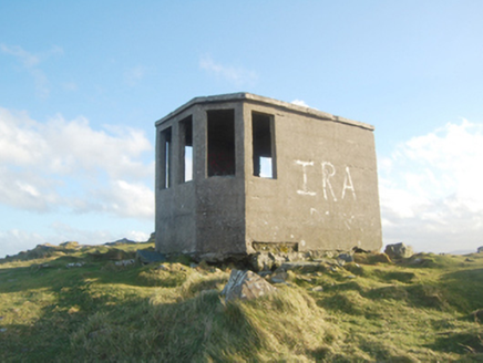 Horn Head Lookout PostWatch tower, signal tower · 1.3 mi
 Coastguard HillMountain / peak · 1.3 mi
 CrocksheeMountain / peak · 1.4 mi
 Horn Head Signal TowerRuins · 1.5 mi
 Tramore StrandBeach / strand · 2.3 mi
 KillahoeyOfficial bathing water · 2.8 mi
 Kill Old Church GraveyardGraveyard · 2.9 mi
 Local Wildlife presentationVisitor information · 3.0 mi
 Dermot and Granias BedPortal tomb · 4.3 mi
Pictures: C Michael Hogan, Wikimedia Commons · CC BY-SA 2.0; Anne Burgess, Wikimedia Commons · CC BY-SA 2.0; N Chadwick, Wikimedia Commons · CC BY-SA 2.0; National Inventory of Architectural Heritage; N Chadwick, Geograph · CC BY-SA 2.0; Chris Gunns, Geograph · CC BY-SA 2.0; Rossographer, Geograph · CC BY-SA 2.0; Ross, Wikimedia Commons · CC BY-SA 2.0; Kenneth Allen, Geograph · CC BY-SA 2.0; Wanfried-Dublin, Wikimedia Commons · CC BY-SA 4.0
More archaeology and monuments in County Donegal · All of County Donegal
What do you know about this place?