
What is recorded here
From OpenStreetMap (© OpenStreetMap contributors) n3792483998
Places near here
Picture notes
- National Inventory of Architectural Heritage
- Computer-made picture. It does not show this mountain top.
- Kenneth Allen, Geograph · Creative Commons Attribution-ShareAlike 2.0
- Kenneth Allen, Geograph · CC BY-SA 2.0
- Computer-made picture. It does not show this walking route.
- Computer-made picture. It does not show this playground.
- Computer-made picture. It does not show this monument.
- louise price, Geograph · CC BY-SA 2.0
 Con's CottageHouse · 1.1 mi
Explorer Tom Con's Cottage in Derrydruel Upper, built c.1860, wears its stone and iron pegs like a safety harness for a very determined straw thatch. I imagine it holding on tight just to prove it can outlast the wind.
 Tangaveane HillMountain / peak · 1.2 miComputer-made picture
Explorer Tom Tangaveane Hill is just waiting for someone to take a selfie and make it famous. Until then, it’s just another peak in the middle of nowhere, which is perfect. Go now, before it gets famous and starts charging admission.
 CroaghnashallogMountain / peak · 1.3 miComputer-made picture
Explorer Tom Croaghnashallog in County Donegal might look like a castle, but it’s definitely just a very fancy rock. Don’t get confused by the architecture, go on, count the windows and get it wrong like I did.
 Traighena National SchoolSchool · 2.0 mi
Explorer Tom Traighena National School has got those decorative vents that look like little eyes peeking out at you. It’s been sticking around since 1911, which makes it older than most of your relatives’ cars. Bring someone who'll believe anything.
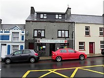 Teach Owenie BánPub · 2.4 mi
Explorer Tom Teach Owenie Bán in Dungloe has a sign that’s falling off the wall, which is very on-brand for the pub. The Irish name is fancy, but the pints are likely mediocre. Keep an eye out for ghosts.
 Slí Na Rosann - Sli Dhun na nGallOfficial walking route · 2.4 miComputer-made picture
Explorer Tom Slí Na Rosann - Sli Dhun na nGall is sixty-four kilometres of pure epic fail waiting to happen. A prophecy says it will vanish by Tuesday, but we all know that’s not true. Tell the kids it's a castle. Close enough.
 Mulhern’s Corner BarPub · 2.4 mi
Explorer Tom Mulhern’s Corner Bar sits right on Lower Main Street, looking down its nose at everyone else. The corner is probably sharp enough to cut your cheek. Ask if they have any stories about the wall.
 Dungloe River Walk incorporating Cope Mountain WalkOfficial walking route · 2.6 miComputer-made picture
Explorer Tom Dungloe River Walk incorporating Cope Mountain Walk is a combo meal of river and mountain that doesn’t really agree with itself. You’ll walk by water, then up a hill, wondering why. It's free, it's odd, what more do you want? Probably shoes.
 Children's playground2.8 miComputer-made picture
Explorer Tom Children's playground in County Donegal once had a fox take charge and reorganise the seating plan according to its own chaotic logic. The kids loved it. Bring biscuits, because every good story needs biscuits.
 Megalithic tomb in Cró Na MadadhMegalithic tomb · 3.0 miComputer-made picture
Explorer Tom Megalithic tomb in Cró Na Madadh is a bit of a mystery, as locals claimed an immense cromlech was here. Turns out it might just be one of those big rocks sitting on the hilltop. You’re essentially staring at a very confused boulder.
 Hut site in Fál ChorbHut site · 3.2 miComputer-made picture
Explorer Tom Hut site in Fál Chorb was described as a low circle of earth and stone on poorly drained ground. A shallow waterlogged ditch lay outside it, and no entrance was visible. The survey's measurements are clear; what the circle was used for is much less so.
 DooeyOfficial bathing water · 4.3 mi
Explorer Tom Dooey seems to have let the Gweebarra estuary and a headland book its two ends. Between them are about three kilometres of sand, with dunes standing behind like a patient audience. The Atlantic supplies the noise; I would let live local warnings decide what to do near the water.
More mountains and hills in County Donegal · All of County Donegal

What do you know about this place?Tap to add a comment or ask a question