What is recorded here
From OpenStreetMap (© OpenStreetMap contributors) n332373385
Places near here
Photo credits
- National Inventory of Architectural Heritage
- Kieran Evans, Wikimedia Commons · CC BY-SA 2.0
- John Cromie, Geograph · CC BY-SA 2.0
- Robert Bone, Wikimedia Commons · CC BY-SA 2.0
- louise price, Wikimedia Commons · CC BY-SA 2.0
- Kenneth Allen, Geograph · CC BY-SA 2.0
- D Gore, Geograph · CC BY-SA 2.0
- Ronnie Nijboer, Wikimedia Commons · CC0
 Catholic Church of the Holy FamilyChurch/chapel · 1.3 mi
Explorer Tom Catholic Church of the Holy Family dates to 1906 and has a four-petal shape set inside a circle above its porch. The stained glass can have its turn too, but that tiny blank shape keeps stealing my attention. It is the church's quietest decoration.
 Graffy BridgeBridge · 1.8 mi
Explorer Tom Graffy Bridge was built around 1830 with two arches over the Stracashel River and an additional arch to the southwest. Cut-stone triangular cutwaters face the flow. I thought the bridge had finished its sentence after two arches; the third adds a cheeky postscript.
 Lavagh MoreMountain / peak · 2.3 mi
Explorer Tom Right then, we’re standing on Lavagh More in County Donegal, and that view to the north-west is pure gold. It’s a proper peak, so keep an eye out for what’s hiding up there.
 Aghla Mountain South TopMountain / peak · 3.0 mi
Explorer Tom Aghla Mountain South Top only shows its face on all-too-rare days when it isn't shrouded in damp mist. I suppose the mountain prefers its curtains drawn most of the time.
 Giant's Grave Megalithic TombMegalithic tomb · 4.3 mi
Explorer Tom Giant's Grave Megalithic Tomb lies deep in boggy ground between Aghla and Scraigs. The recorded gallery was five metres long, with six stones on each side. A slab across one end might not have been part of its original roof. That uncertainty is more interesting than pretending the wet ground offers an easy look inside.
 Dolmen at DisertPublicly named tomb or grave · 4.8 mi
Explorer Tom Dolmen at Disert is supposedly where a chieftain druid went to sleep. I bet he cast a really long nap spell and forgot the wake-up word! Now he’s just napping under the stones, probably snoring in ancient Gaelic.
 Disert GraveyardGraveyard · 4.9 mi
Explorer Tom Disert Graveyard is a D-shaped pocket inside two larger enclosures, with at least 34 low uninscribed grave markers noted across its centre. The account also records a striking custom: people took soil from near the altar because it was reputed to drive rats from houses. I'd keep that as a belief people held, not a promise from the place.
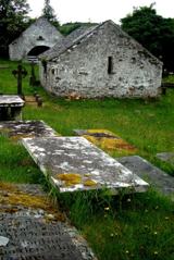 Inishkeel Graveyard near GlentiesGraveyard · 5.4 mi
Explorer Tom Inishkeel Graveyard near Glenties was rectangular in the older survey, but its south side sat on part of a roughly circular rise. Some of that rise lay beyond the west wall, about fifty metres across. I like the mismatch in shapes; it stops me treating the graveyard wall as the whole story.
 St. Connell's Museum and Heritage CentreMuseum · 6.1 mi
Explorer Tom St. Connell's Museum and Heritage Centre lets me go from an old courtroom to the cells below, then into stories of the workhouse and Donegal railways. That is a lot of Glenties history packed into one building. I would leave the cells to the displays and keep my own visit on the friendly side of the door.
 Ard na Mona WoodOfficial walking route · 6.7 mi
Explorer Tom Ard na Mona Wood is a 1.9 km loop in County Donegal, taking you through rare ancient oak woodland near Lough Eske.
 Wych Elm8.5 mi
Explorer Tom Another fine Wych Elm awaits in County Donegal, so remember to check if you need permission first.
 Donegal Railway Heritage CentreMuseum · 9.6 mi
Explorer Tom Donegal Railway Heritage Centre keeps the county's railway stories in an old station house, including the 1907 Drumboe engine and an interactive cab. I would begin with the engine, then try the cab to see what a driver watched. At last, a railway stop where I am allowed to stay awhile.
More mountains and hills in County Donegal · All of County Donegal
What do you know about this place?