
Places near here
Photo credits
- National Inventory of Architectural Heritage
- Mike Searle, Geograph · CC BY-SA 2.0
- Jonathan Billinger, Geograph · CC BY-SA 2.0
- Richard Webb, Geograph · CC BY-SA 2.0
- Jonathan Billinger, Wikimedia Commons · CC BY-SA 2.0
 rectory/glebe/vicarage/curate's house373 yd
Explorer Tom Rectory in Clashadoo, County Cork is a former glebe house from around 1820. It used to be part of a church complex, so there might still be some very old hymns trapped inside the walls.
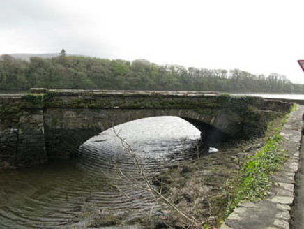 bridge409 yd
Explorer Tom Bridge in Clashadoo is a single-arch limestone structure from 1830 spanning a stream. It’s got dressed ashlar voussoirs that show off some serious craftsmanship. It stands there looking very pleased with itself, honestly, just standing there doing nothing much.
 Coolnalong Castle (in Ruins)House, fortified house · 824 yd
Explorer Tom Coolnalong Castle is a U-shaped house that looks like it's trying to hug itself. It overlooks Dunmanus Bay and has some fancy oversailing chimney caps. It’s been used as a farm building, so maybe smell the cows before you explore.
Burial Ground (Disused)Burial ground · 1071 ydExplorer Tom Burial Ground (Disused) in Clashadoo is an oval-shaped patch on a sunny slope. It’s defined by some grave markers and plenty of overgrowth that seems to be winning the battle. It’s disused, so the dead are probably just enjoying the silence down there. No rush to visit them.
Mannion's Island (Small)Islet · 1372 yd Rossmore Castle (in Ruins)Castle, tower house · 1484 yd
Explorer Tom Rossmore Castle is ivy-clad and dramatic on Dunmanus Bay, looking like it was dressed for a photo shoot. It was nearly sold for a horse, which is a great deal actually. Pick a stone, any stone, and invent its entire biography on the spot.
Mannion's Island (Large)Islet · 1680 ydLisdromalogheraEnclosure · 1.0 miExplorer Tom Lisdromaloghera is just a big pile of dirt pretending to be fancy. The builder probably fell asleep mid-project and never bothered to finish the job properly, which is why it looks so confused. Best visited with a curious kid and no timetable.
KilbreaghMountain / peak · 1.5 mi Mount CorrinMountain / peak · 1.7 miCoomkeen Loop WalkWalking route · 1.8 mi
 Durrus CheeseVisitor attraction · 2.0 mi
More archaeology and monuments in County Cork · All of County Cork

What do you know about this place?Tap to add a comment or ask a question